Llanwenarth: Difference between revisions
m clean up, typos fixed: of of → of |
No edit summary |
||
| Line 2: | Line 2: | ||
|name=Llanwenarth | |name=Llanwenarth | ||
|county=Monmouthshire | |county=Monmouthshire | ||
|picture= | |picture=St Peter's Church, Llanwenarth, Llanfoist Fawr.JPG | ||
|picture caption= | |picture caption=St Peter's Church | ||
|os grid ref=SO2763013686 | |os grid ref=SO2763013686 | ||
|latitude=51.816667 | |latitude=51.816667 | ||
| Line 18: | Line 18: | ||
== Location == | == Location == | ||
Llanwenarth is located two miles west of the market town of [[Abergavenny]], close to the banks of the River Usk.<ref>[http://www.geograph.org.uk/photo/461717 The Usk: OS grid SO2814] at geograph.org</ref> | Llanwenarth is located two miles west of the market town of [[Abergavenny]], close to the banks of the River Usk.<ref>[http://www.geograph.org.uk/photo/461717 The Usk: OS grid SO2814] at geograph.org</ref> The ancient parish is divided by the Usk into the two hamlets of Llanwenarth Citra and Llanwenarth Ultra. | ||
== History and amenities == | == History and amenities == | ||
The village has a church dedicated to St | The village has a church dedicated to St Peter: an ogival-headed priest's doorway in the chancel, and two windows with reticulated tracery are assigned to the fourteenth century, and a lancet in the west wall of the nave seems to be from the thirteenth,<ref>Mike salter, ''The Old Parish Churches of Gwent, Glamorgan and Gower'', Folly Publications, Malvern 2002.</ref> where a square tower with battlemented top was added later. The village once had a Victorian schoolhouse, now demolished. The village, in Llanwenarth Citra, sits in flattish grassy pastures<ref>[http://www.geograph.org.uk/photo/447541 Farmland near Llanwenarth] at geograph.org</ref> between the [[Blorenge]] mountain and the [[Sugar Loaf, Monmouthshire|Sugar Loaf]]. Some of these meadows have been designated a Site of Special Scientific Interest. Llanwenarth House was built in the 16th century and is operated as a hotel, located to the west of nearby [[Govilon]]. | ||
The busy A40 Abergavenny to [[Brecon]] road passes along the valley side above the flood plain of the River Usk, and Nevill Hall Hospital is situated close by on the outskirts of Abergavenny town. | The busy A40 Abergavenny to [[Brecon]] road passes along the valley side above the flood plain of the River Usk, and Nevill Hall Hospital is situated close by on the outskirts of Abergavenny town. | ||
| Line 27: | Line 27: | ||
The annual Abergavenny and Border Counties agricultural show used to be held on the fields close to the church until the 1990s. | The annual Abergavenny and Border Counties agricultural show used to be held on the fields close to the church until the 1990s. | ||
An old cable ferry (similar to Hampton Loade Ferry on the [[River Severn]]) used to be used in Victorian times to cross the River Usk from a field on the Abergavenny/Llanwenarth side to the Govilon side of the river | An old cable ferry (similar to Hampton Loade Ferry on the [[River Severn]]) used to be used in Victorian times to cross the River Usk from a field on the Abergavenny/Llanwenarth Citra side to the Govilon side of the river in Llanwenarth Ultra. | ||
==References== | ==References== | ||
Latest revision as of 15:25, 1 December 2017
| Llanwenarth | |
| Monmouthshire | |
|---|---|
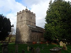
 St Peter's Church | |
| Location | |
| Grid reference: | SO2763013686 |
| Location: | 51°49’0"N, 3°3’-0"W |
| Data | |
| Post town: | Abergavenny |
| Postcode: | NP7 |
| Dialling code: | 01873 |
| Local Government | |
| Council: | Monmouthshire |
| Parliamentary constituency: |
Monmouth |
Llanwenarth is a small village and ancient parish in the Vale of Usk of Monmouthshire. For civil purposes it forms part of Llanfoist Fawr.
Location
Llanwenarth is located two miles west of the market town of Abergavenny, close to the banks of the River Usk.[1] The ancient parish is divided by the Usk into the two hamlets of Llanwenarth Citra and Llanwenarth Ultra.
History and amenities
The village has a church dedicated to St Peter: an ogival-headed priest's doorway in the chancel, and two windows with reticulated tracery are assigned to the fourteenth century, and a lancet in the west wall of the nave seems to be from the thirteenth,[2] where a square tower with battlemented top was added later. The village once had a Victorian schoolhouse, now demolished. The village, in Llanwenarth Citra, sits in flattish grassy pastures[3] between the Blorenge mountain and the Sugar Loaf. Some of these meadows have been designated a Site of Special Scientific Interest. Llanwenarth House was built in the 16th century and is operated as a hotel, located to the west of nearby Govilon.
The busy A40 Abergavenny to Brecon road passes along the valley side above the flood plain of the River Usk, and Nevill Hall Hospital is situated close by on the outskirts of Abergavenny town.
The annual Abergavenny and Border Counties agricultural show used to be held on the fields close to the church until the 1990s.
An old cable ferry (similar to Hampton Loade Ferry on the River Severn) used to be used in Victorian times to cross the River Usk from a field on the Abergavenny/Llanwenarth Citra side to the Govilon side of the river in Llanwenarth Ultra.
References
- ↑ The Usk: OS grid SO2814 at geograph.org
- ↑ Mike salter, The Old Parish Churches of Gwent, Glamorgan and Gower, Folly Publications, Malvern 2002.
- ↑ Farmland near Llanwenarth at geograph.org
Outside links

This Monmouthshire article is a stub: help to improve Wikishire by building it up.