Providenciales: Difference between revisions
Created page with '{{Infobox island |name=Providenciales |group=Caicos Islands |territory=Turks and Caicos Islands |area=38 square miles |population= |census year= |picture=Turtle Cove Providencial…' |
|||
| (One intermediate revision by the same user not shown) | |||
| Line 8: | Line 8: | ||
|picture=Turtle Cove Providenciales Beach.jpg | |picture=Turtle Cove Providenciales Beach.jpg | ||
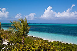
|picture caption=Turtle Cove, Providenciales | |picture caption=Turtle Cove, Providenciales | ||
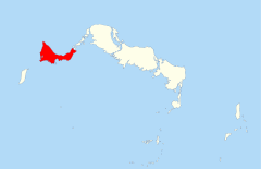
|map= | |map=Providenciales T&C.svg | ||
}} | }} | ||
'''Providenciales''' is an island at the western end of the chain of the [[Caicos Islands]]. It is the most populous island of the [[Turks and Caicos Islands]]. | '''Providenciales''' is an island at the western end of the chain of the [[Caicos Islands]]. It is the most populous island of the [[Turks and Caicos Islands]]. | ||
| Line 35: | Line 35: | ||
==Providenciales Town== | ==Providenciales Town== | ||
{{Main|Providenciales Town}} | {{Main|Providenciales Town}} | ||
The only town in the island is named after the island itself. The majority of the islands services are in this town such as | The only town in the island is named after the island itself. The majority of the islands' services are in this town such as shopping malls. In addition to being a tourist hotspot, shacks thrown up by Haitian refugees can also be seen in the town. | ||
==Pictures== | ==Pictures== | ||
Latest revision as of 22:32, 25 November 2017
| Providenciales | |
 Turtle Cove, Providenciales | |
|---|---|
| Location | |
| Area: | 38 square miles |
| Data | |
Providenciales is an island at the western end of the chain of the Caicos Islands. It is the most populous island of the Turks and Caicos Islands.
The island is known locally as Provo. It has an area of 38 square miles and an approximate population of 32,000 in 2012, making it the largest island in population and the third largest in area. It is served by the Providenciales International Airport.
The east of the island has become thickly populated. The western half of Providenciales though is mostly barren wilderness, home to the island's best natural attraction, Chalk Sound National Park. The park is a bay 3 miles long southwest of Downtown. The colour of the water is a uniform turquoise and studded with countless mushroom-like tiny islets. Also on the western part of the island is Northwest Point Marine National Park, which extends to nearby reefs and several saline lakes that attract breeding and migrant waterfowl.
The communities of Downtown and Kew Town are near the airport. The major road, the Highway, runs east-west from Downtown to Leeward. Most of the island's services are near the Highway, including upscale shopping malls. They are also found in the commercial developments of Grace Bay, in support of the tourism market.
Opportunities for sightseeing and hiking are reasonable. At Osprey Rock and Sapodilla Hill there are traces left from the high days of the pirates of the Caribbean. Also notable are the ruins of Cheshire Hall, a 1790s plantation house constructed by United Empire Loyalists.
Holiday and residential development
Providenciales was ranked the best beach destination in the world by TripAdvisor in 2011.[1]
As recently as 1964, Providenciales did not have a single wheeled vehicle. Following in the footsteps of Club Med, the island's first large hotel and casino complex opened in 1984 and touched off a development boom. Provo is now the most tourist-oriented and developed of the Turks and Caicos Islands, boasting many resort hotels and an 18-hole golf course. The island has recently become popular with retired folk from around the world, kindling a boom of residential development. Grace Bay has seen many luxury blocks built on its shores, though the dwellings of the local Islanders still provide a local flair to the island.
The resorts on Providenciales are primarily centred on 5-mile long Grace Bay. Apart from the beaches, the island's charm lies in its rugged hills and ridges, which are carpeted with prickly pear cactus and scrub. The trump card, however, remains the world class diving: miles and miles of coral reefs are close to shore and the island is close to a common migration route for the Humpback whale.
Providenciales is surrounded by uninhabited cays that are easily reached by chartered boat or excursion.
Before Provo became a popular tourist destination, there were three small centres of population: Blue Hills, The Bight (on Grace Bay) and Five Cays. Now many houses have been built, predominantly in the east and south, with larger communities at Leeward, Long Bay and Chalk Sound, as well as expansion of the original three settlements. There are also pockets of makeshift shacks interspersed among the more upscale residences.
Grace Bay has grown to be a major tourist destination with many hotels and apartment blocks built on the beach front.
Providenciales Town
- Main article: Providenciales Town
The only town in the island is named after the island itself. The majority of the islands' services are in this town such as shopping malls. In addition to being a tourist hotspot, shacks thrown up by Haitian refugees can also be seen in the town.
Pictures
-
Chalk Sound
-
Providenciales Mangrove Reflections
-
Providenciales Town Centre Mall
-
Turks and Caicos Airport Hotel
-
The Leeward Highway
-
The Leeward Highway
-
Providenciales International Airport
-
A Blue Chromis in Providenciales
-
A French Angelfish in Providenciales
-
A Stoplight Parrotfish in Providenciales
-
A Sergeant Major in Providenciales
-
A Blue Tang and Squirrelfish in Providenciales
References
- ↑ Zay, Libby. "Trip Advisor Names Top Beach Destinations". AOL Travel. http://news.travel.aol.com/2011/04/05/tripadvisor-names-top-beach-destinations/. Retrieved 14 April 2011.


