Aghagallon: Difference between revisions
Created page with '{{Infobox town |name=Aghagallon |county=Antrim |picture= |picture caption= |os grid ref=J1063 |LG district=Craigavon }} '''Aghagallon''' is a village in County Antrim. {{stu…' |
No edit summary |
||
| Line 1: | Line 1: | ||
{{Infobox town | {{Infobox town | ||
|name=Aghagallon | |name=Aghagallon | ||
|county=Antrim | |county=Antrim | ||
|picture= | |townland=yes | ||
|picture caption= | |picture=St Patrick's Church, Aghagallon - geograph.org.uk - 125695.jpg | ||
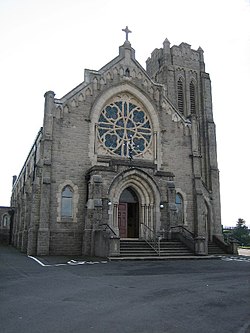
|os grid ref= | |picture caption=St Patrick's Catholic church, Aghagallon | ||
|os grid ref=J104636 | |||
|latitude=54.509 | |||
|longitude=-6.294 | |||
|population=824 | |||
|census year=2001 | |||
|post town=Craigavon | |||
|postcode=BT67 | |||
|dialling code=028 | |||
|LG district=Craigavon | |LG district=Craigavon | ||
|constituency=Upper Bann | |||
}} | }} | ||
'''Aghagallon''' is a village in [[County Antrim]]. | '''Aghagallon''' is a small village in [[County Antrim]], about three miles northeast of [[Lurgan]] and close to the south-east corner of [[Lough Neagh]]. | ||
{{ | The name of the village is believed to come from the Gaelic ''Achadh Gallan'', meaning "Field of the standing stone".<ref name=logainm>[http://www.logainm.ie/1411783.aspx Placenames Database of Ireland]</ref> | ||
Aghagallon had a recorded population of 824 in the 2001 census, and is over 90% Roman Catholic. The Farm Census 2010 recorded 89 farms registered to addresses in Aghagallon, and the total agricultural labour force was 170 persons. | |||
The village has mainly developed along Aghalee Road in a linear fashion with development to the southeast along Colane Road. St Patrick’s Church and the adjacent primary school are in the middle of the village. Although the village is named after the [[townland]] of Aghagallon, it lies almost wholly within neighbouring Derrynaseer townland. | |||
==Townlands of Aghagallon Parish== | |||
The parish of Aghagallon consists of 13 townlands; Aghadrumglasny, Aghagallon, Ballycairn, Ballykeel, Ballymacilrany, Derryclone, Derryhirk, Derrymore, Derrynaseer, Drumaleet, Montiaghs, Tamnyvane, and Tiscallen, | |||
==The Three Pronged Revolver== | |||
An incident that took place in Aghagallon in 1790 became known as "The Battle of Annaghdroghal Bridge". A group of Protestant men from the nearby village of [[Waringstown]], accompanied by flute and drum and under the command of Colonel Sharp, marched from Waringstown at the request of Lord Waring to plough and prepare a field in Aghagallon for a friend and fellow landowner and Orangeman. Their journey from Waringstown to Aghagallon was a controversial one, with several incidents occurring along the way in the town of [[Lurgan]]. | |||
As Col. Sharp and his men reached the Annaghdroghal Bridge just east of Aghagallon they were met by local men who refused them passage. A fight incurred and the Battle of Annaghdroghal began. Col. Sharp led his men in the first attack and was fatally wounded by "The Darkie" McStravick, receiving a chest wound from a three pronged muck fork. McStravick fled the scene and dumped the fork (The Three Pronged Revolver) down a dry well at Derryclone. The fork was retrieved around 1890 from the well and was presented to a local museum by Phelim McStravick in 2008. | |||
==Sport== | |||
*Gaelic Athletic: ''Naomh Mhuire | |||
*Football: Aghagallon Magners | |||
==References== | |||
{{reflist}} | |||
Latest revision as of 14:01, 18 October 2017
| Aghagallon | |
| County Antrim | |
|---|---|
 St Patrick's Catholic church, Aghagallon | |
| Location | |
| Grid reference: | J104636 |
| Location: | 54°30’32"N, 6°17’38"W |
| Data | |
| Population: | 824 (2001) |
| Post town: | Craigavon |
| Postcode: | BT67 |
| Dialling code: | 028 |
| Local Government | |
| Council: | Armagh, Banbridge and Craigavon |
| Parliamentary constituency: |
Upper Bann |
Aghagallon is a small village in County Antrim, about three miles northeast of Lurgan and close to the south-east corner of Lough Neagh.
The name of the village is believed to come from the Gaelic Achadh Gallan, meaning "Field of the standing stone".[1]
Aghagallon had a recorded population of 824 in the 2001 census, and is over 90% Roman Catholic. The Farm Census 2010 recorded 89 farms registered to addresses in Aghagallon, and the total agricultural labour force was 170 persons.
The village has mainly developed along Aghalee Road in a linear fashion with development to the southeast along Colane Road. St Patrick’s Church and the adjacent primary school are in the middle of the village. Although the village is named after the townland of Aghagallon, it lies almost wholly within neighbouring Derrynaseer townland.
Townlands of Aghagallon Parish
The parish of Aghagallon consists of 13 townlands; Aghadrumglasny, Aghagallon, Ballycairn, Ballykeel, Ballymacilrany, Derryclone, Derryhirk, Derrymore, Derrynaseer, Drumaleet, Montiaghs, Tamnyvane, and Tiscallen,
The Three Pronged Revolver
An incident that took place in Aghagallon in 1790 became known as "The Battle of Annaghdroghal Bridge". A group of Protestant men from the nearby village of Waringstown, accompanied by flute and drum and under the command of Colonel Sharp, marched from Waringstown at the request of Lord Waring to plough and prepare a field in Aghagallon for a friend and fellow landowner and Orangeman. Their journey from Waringstown to Aghagallon was a controversial one, with several incidents occurring along the way in the town of Lurgan.
As Col. Sharp and his men reached the Annaghdroghal Bridge just east of Aghagallon they were met by local men who refused them passage. A fight incurred and the Battle of Annaghdroghal began. Col. Sharp led his men in the first attack and was fatally wounded by "The Darkie" McStravick, receiving a chest wound from a three pronged muck fork. McStravick fled the scene and dumped the fork (The Three Pronged Revolver) down a dry well at Derryclone. The fork was retrieved around 1890 from the well and was presented to a local museum by Phelim McStravick in 2008.
Sport
- Gaelic Athletic: Naomh Mhuire
- Football: Aghagallon Magners