Weddell Sea: Difference between revisions
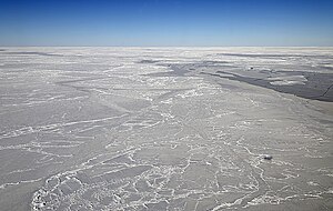
Created page with 'thumb|250px|right|An aerial view of Antarctica (Weddell Sea top left bight The '''Weddell Sea''' is part of the Southern Ocean and…' |
No edit summary |
||
| Line 2: | Line 2: | ||
The '''Weddell Sea''' is part of the Southern Ocean and contains the Weddell Gyre. Its land boundaries are defined by the bay formed from the coasts of [[Coats Land]] and the [[Antarctic Peninsula]]. The easternmost point is Cape Norvegia at Princess Martha Coast of the Norwegian Antarctic Territory. | The '''Weddell Sea''' is part of the Southern Ocean and contains the Weddell Gyre. Its land boundaries are defined by the bay formed from the coasts of [[Coats Land]] and the [[Antarctic Peninsula]]. The easternmost point is Cape Norvegia at Princess Martha Coast of the Norwegian Antarctic Territory. | ||
Much of the southern part of the sea, up to [[Elephant Island]], is permanent ice, the [[Filchner | Much of the southern part of the sea, up to [[Elephant Island]], is permanent ice, the [[Filchner Ice Shelf|Filchner]] and [[Ronne Ice Shelf|Ronne]] Ice Shelves. The coasts of the sea and its islands are contained within the [[British Antarctic Territory]]. At its widest the sea is around 1,250 miles across, and in area it is around 1,000,000 square miles. | ||
==Exploration== | ==Exploration== | ||
| Line 17: | Line 17: | ||
==The sea and sea coasts== | ==The sea and sea coasts== | ||
Various ice shelves, including the [[Filchner | Various ice shelves, including the [[Filchner Ice Shelf|Filchner]] and [[Ronne Ice Shelf|Ronne]] Ice Shelves, fringe the Weddell Sea. Some of the ice shelves on the east side of the [[Antarctic Peninsula]], which used to extend roughly 3,900 square miles over the Weddell Sea, had completely disappeared by 2002. Whilst this is dramatic, the area that disappeared was far smaller than the total area of ice shelf that remains. | ||
Characteristic fauna of the sea include the Weddell Seal. | Characteristic fauna of the sea include the Weddell Seal. | ||
Latest revision as of 21:19, 24 May 2017

The Weddell Sea is part of the Southern Ocean and contains the Weddell Gyre. Its land boundaries are defined by the bay formed from the coasts of Coats Land and the Antarctic Peninsula. The easternmost point is Cape Norvegia at Princess Martha Coast of the Norwegian Antarctic Territory.
Much of the southern part of the sea, up to Elephant Island, is permanent ice, the Filchner and Ronne Ice Shelves. The coasts of the sea and its islands are contained within the British Antarctic Territory. At its widest the sea is around 1,250 miles across, and in area it is around 1,000,000 square miles.
Exploration

The sea is named after the British sailor James Weddell who entered the sea in 1823 as far as 74°S. That same year the American sealing captain Benjamin Morrell claimed to have seen land some 10–12° east of the sea's actual eastern boundary. He called this New South Greenland, but its existence was disproved when the sea was more fully explored in the early 20th century.
The furthest southern penetration since Weddell but before the modern era was made by the William Speirs Bruce in 1903.
In his 1950 book The White Continent, historian Thomas R Henry writes:
| “ | The Weddell Sea is, according to the testimony of all who have sailed through its berg-filled waters, the most treacherous and dismal region on earth. The Ross Sea is the relatively peaceful, predictable, and safe. | ” |
He continues on for an entire chapter, relating myths of the green-haired merman sighted in the sea's icy waters, the inability of crews to navigate a path to the coast until 1949, and treacherous "flash freezes" that left ships, such as Ernest Shackleton's Endurance, at the mercy of the ice floes.
The sea and sea coasts
Various ice shelves, including the Filchner and Ronne Ice Shelves, fringe the Weddell Sea. Some of the ice shelves on the east side of the Antarctic Peninsula, which used to extend roughly 3,900 square miles over the Weddell Sea, had completely disappeared by 2002. Whilst this is dramatic, the area that disappeared was far smaller than the total area of ice shelf that remains.
Characteristic fauna of the sea include the Weddell Seal.
The Weddell Sea has been deemed by scientists to have the clearest water of any sea. Dutch researchers from the German Alfred Wegener Institute, on finding a Secchi disc visible at a depth of 262 feet on October 13, 1986, ascertained that the clarity corresponded to that of distilled water.
The Weddell Sea is an important area of deep water mass formation through cabbeling, the main driving force of the thermohaline circulation. Deep water masses are also formed through cabbeling in the North Atlantic and are caused by differences in temperature and salinity of the water. In the Weddell sea this is brought about mainly by brine exclusion and wind cooling.
Flash freezing is a common occurrence in the Weddell Sea.
Outside links
- Foraminifera of the Weddell Sea bottom – Deep Sea Foraminifera from 4400m depth - an image gallery of hundreds of specimens and description