River Findhorn: Difference between revisions
Created page with 'thumb|right|300px|The Findhorn just east of Tomatin The '''River Findhorn''' is one of the longest rivers in the Highlands, rising amo…' |
No edit summary |
||
| (One intermediate revision by the same user not shown) | |||
| Line 1: | Line 1: | ||
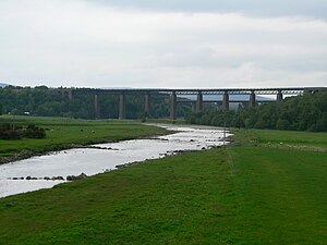
[[File:Tomatin railway viaduct 01.jpg|thumb|right|300px|The Findhorn just east of Tomatin]] | [[File:Tomatin railway viaduct 01.jpg|thumb|right|300px|The Findhorn just east of Tomatin]] | ||
{{county|Moray}} | |||
The '''River Findhorn''' is one of the longest rivers in the [[Highlands]], rising amongst the high mountains and flowing down to the [[Moray Firth]] at [[Findhorn]] in [[Morayshire]]. The Findhorn enters the sea through a broad, sheltered estuary. | The '''River Findhorn''' is one of the longest rivers in the [[Highlands]], rising amongst the high mountains and flowing down to the [[Moray Firth]] at [[Findhorn]] in [[Morayshire]]. The Findhorn enters the sea through a broad, sheltered estuary. | ||
| Line 7: | Line 8: | ||
==Course== | ==Course== | ||
The River Findhorn has its source in the [[Monadhliath Mountains of Inverness-shire]]. From here it flows down, north-eastwards, crossing into [[Nairnshire]] towards the coastal plain, and finally into [[Morayshire]] and the town on [[Findhorn]], where its waters fill a large natural harbour before opening into the sea. | The River Findhorn has its source in the [[Monadhliath Mountains]] of [[Inverness-shire]]. From here it flows down, north-eastwards, crossing into [[Nairnshire]] towards the coastal plain, and finally into [[Morayshire]] and the town on [[Findhorn]], where its waters fill a large natural harbour before opening into the sea. | ||
==Tributaries== | ==Tributaries== | ||
| Line 42: | Line 43: | ||
* [[Findhorn]] | * [[Findhorn]] | ||
{{ | *Location map: {{wmap|57.633|-3.633}} | ||
{{DEFAULTSORT:Findhorn River}} | |||
[[Category:Rivers of Inverness-shire]] | [[Category:Rivers of Inverness-shire]] | ||
[[Category:Rivers of Nairnshire]] | [[Category:Rivers of Nairnshire]] | ||
[[Category:Rivers of Morayshire]] | [[Category:Rivers of Morayshire]] | ||
Latest revision as of 20:11, 4 May 2017

The River Findhorn is one of the longest rivers in the Highlands, rising amongst the high mountains and flowing down to the Moray Firth at Findhorn in Morayshire. The Findhorn enters the sea through a broad, sheltered estuary.
The river provides excellent salmon and trout fishing and is popular with anglers from across the globe. It is also a classic white water kayaking rivers (varying from grade 2 to 4) and draws canoeists from across the country.
Its name is Gaelic is Uisge Èireann.
Course
The River Findhorn has its source in the Monadhliath Mountains of Inverness-shire. From here it flows down, north-eastwards, crossing into Nairnshire towards the coastal plain, and finally into Morayshire and the town on Findhorn, where its waters fill a large natural harbour before opening into the sea.
Tributaries
(from source to mouth)
- River Cro-chlach
- River Eskin
- Elrick Burn
- Funtack Burn
- Rhilean Burn
- Leonach Burn
- Tomlach Burn
- Red Burn
- Derback Burn
- Muckle Burn
Towns and villages on the river
(from source to mouth)
- Dalmigavie
- Corrievorrie
- Kyllachy
- Findhorn Bridge
- Tomatin
- Inverbrough
- Ruthven
- Streens
- Dulsie
- Glenferness
- Ardclach
- Ferness
- Relugas
- Altyre
- Forres
- Kinloss
- Findhorn
- Location map: 57.633 -3.633