Woll: Difference between revisions
Jump to navigation
Jump to search
Created page with "{{Infobox town |name=Woll |county=Roxburghshire |picture= |picture caption= |os grid ref=NT465221 |latitude=55.490185 |longitude=-2.846969 |postcode= |post town= |population=..." |
mNo edit summary |
||
| Line 2: | Line 2: | ||
|name=Woll | |name=Woll | ||
|county=Roxburghshire | |county=Roxburghshire | ||
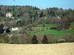
|picture= | |picture=The Woll viewed from the layby on the A7 south of Ashkirk - geograph.org.uk - 1730104.jpg | ||
|picture caption= | |picture caption= | ||
|os grid ref=NT465221 | |os grid ref=NT465221 | ||
Latest revision as of 22:52, 6 February 2017
| Woll | |
| Roxburghshire | |
|---|---|

| |
| Location | |
| Grid reference: | NT465221 |
| Location: | 55°29’25"N, 2°50’49"W |
| Data | |
| Local Government | |
| Council: | Scottish Borders |
Woll is a tiny village in Roxburghshire, on the Ale Water north of Hawick and south of Selkirk. It is within the Ettrick Forest and may be found off the A7 road.