The Wiss: Difference between revisions
Jump to navigation
Jump to search
Created page with "{{Infobox hill |name=The Wiss |county=Selkirkshire |range=Ettrick Forest |picture=Summit, The WIss - geograph.org.uk - 125865.jpg |picture caption=The summit of the Wiss |os g..." |
No edit summary |
||
| Line 2: | Line 2: | ||
|name=The Wiss | |name=The Wiss | ||
|county=Selkirkshire | |county=Selkirkshire | ||
|range=Ettrick | |range=Ettrick Hills | ||
|picture=Summit, The WIss - geograph.org.uk - 125865.jpg | |picture=Summit, The WIss - geograph.org.uk - 125865.jpg | ||
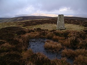
|picture caption=The summit of the Wiss | |picture caption=The summit of the Wiss | ||
| Line 15: | Line 15: | ||
The summit is crowned with a trig point. | The summit is crowned with a trig point. | ||
==Peat Law== | |||
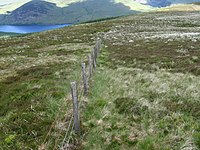
[[File: Peat Law towards St Mary's Loch - geograph.org.uk - 844531.jpg|left|thumb|200px|Peat Law, looking to the loch]] | [[File: Peat Law towards St Mary's Loch - geograph.org.uk - 844531.jpg|left|thumb|200px|Peat Law, looking to the loch]] | ||
'''Peat Law''' is a subsidiary top to the north, which reaches 1,742 feet above sea level. | '''Peat Law''' is a subsidiary top to the north, which reaches 1,742 feet above sea level. | ||
Latest revision as of 23:45, 1 February 2017
| The Wiss | |||
| Selkirkshire | |||
|---|---|---|---|
 The summit of the Wiss | |||
| Range: | Ettrick Hills | ||
| Summit: | 1,932 feet NT264206 55°28’26"N, 3°9’53"W | ||
The Wiss is a hill of 1,932 feet in the Ettrick Forest, overlooking St Mary's Loch. It is the highest point of the broad ridge between the Yarrow Water and the Ettrick Water.
The summit is crowned with a trig point.
Peat Law

Peat Law is a subsidiary top to the north, which reaches 1,742 feet above sea level.