Cranshaws: Difference between revisions
Jump to navigation
Jump to search
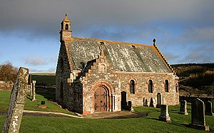
Created page with "{{county|Berwickshire}} thumb|right|Cranshaws Parish Church '''Cranshaws''' is a village in Berwickshire a..." |
No edit summary |
||
| Line 1: | Line 1: | ||
{{county|Berwickshire}} | {{county|Berwickshire}} | ||
[[File:Cranshaws Parish Church - geograph.org.uk - 1588604.jpg|thumb|right|Cranshaws Parish Church]] | [[File:Cranshaws Parish Church - geograph.org.uk - 1588604.jpg|thumb|right|Cranshaws Parish Church]] | ||
'''Cranshaws''' is a village in [[Berwickshire]] adjacent to the border with [[East Lothian]]. It is located nine miles north-west of [[Duns]] via the B6355 road. | '''Cranshaws''' is a village and parish in [[Berwickshire]] adjacent to the border with [[East Lothian]]. It is located nine miles north-west of [[Duns]] via the B6355 road. | ||
Of Cranshaws Castle only the tower remains, at Cranshaws Farm on Cranshaws Hill. | Of Cranshaws Castle only the tower remains, at Cranshaws Farm on Cranshaws Hill. | ||
Places nearby include [[Abbey St Bathans]] | Places nearby include [[Abbey St Bathans]] to the east; [[Duns]] and [[Longformacus]] to the south; and [[Whittingehame]], [[Stenton]] and [[Innerwick]] (in East Lothian) to the north. The [[Whiteadder Water]] flows through the parish and forms part of its northern boundary. | ||
==References== | ==References== | ||
| Line 12: | Line 12: | ||
==Outside links== | ==Outside links== | ||
*Map: {{wmap|55.85|-2.517}} | *Map: {{wmap|55.85|-2.517|zoom=13}} | ||
*[http://canmore.rcahms.gov.uk/en/site/57528/details/cranshaws+old+parish+church+and+churchyard/ CANMORE/RCAHMS record of Cranshaws, Old Parish Church And Churchyard] | *[http://canmore.rcahms.gov.uk/en/site/57528/details/cranshaws+old+parish+church+and+churchyard/ CANMORE/RCAHMS record of Cranshaws, Old Parish Church And Churchyard] | ||
*[http://www.scotlandsplaces.gov.uk/search_item/index.php?service=RCAHMS&id=219804 RCAHMS record of Cranshaws Farm, Stable Courtyard] | *[http://www.scotlandsplaces.gov.uk/search_item/index.php?service=RCAHMS&id=219804 RCAHMS record of Cranshaws Farm, Stable Courtyard] | ||
Latest revision as of 12:47, 18 May 2016

Cranshaws is a village and parish in Berwickshire adjacent to the border with East Lothian. It is located nine miles north-west of Duns via the B6355 road.
Of Cranshaws Castle only the tower remains, at Cranshaws Farm on Cranshaws Hill.
Places nearby include Abbey St Bathans to the east; Duns and Longformacus to the south; and Whittingehame, Stenton and Innerwick (in East Lothian) to the north. The Whiteadder Water flows through the parish and forms part of its northern boundary.
References
- Brooke, C J (2000) Safe sanctuaries: security and defence in Anglo-Scottish border churches 1290-1690, Edinburgh, pages 50-1
- Elma Fleming, Berwickshire Monumental Inscriptions XIII Cranshaws, publ. Borders Family History Society
Outside links
- Map: 55°51’0"N, 2°31’1"W
- CANMORE/RCAHMS record of Cranshaws, Old Parish Church And Churchyard
- RCAHMS record of Cranshaws Farm, Stable Courtyard
- RCAHMS record of Cranshaws Castle
- Ancient Stones: Nine Stone Rig, Cranshaws
- Geograph image: Cranshaws Kirk
- Geograph image: Cranshaws Castle, only the tower remains
- Lammermuir Life: Cranshaws Kirk