Llandough juxta Cardiff: Difference between revisions
Created page with "{{Hatnote|For Llandough near Cowbridge, see Llandough juxta Cowbridge}} {{Infobox town |county=Glamorgan ||latitude=51.449167 |longitude=-3.196667 |picture=Llandough Hospi..." |
No edit summary |
||
| (One intermediate revision by the same user not shown) | |||
| Line 12: | Line 12: | ||
|census year=2011<ref>{{cite web|url=https://neighbourhood.statistics.gov.uk/dissemination/LeadKeyFigures.do?a=7&b=11125831&c=CF64+2PA&d=16&e=62&g=6494396&i=1001x1003x1032x1004&m=0&r=0&s=1428591098000&enc=1|title=Community and Ward population 2011 |accessdate=9 April 2015}}</ref> | |census year=2011<ref>{{cite web|url=https://neighbourhood.statistics.gov.uk/dissemination/LeadKeyFigures.do?a=7&b=11125831&c=CF64+2PA&d=16&e=62&g=6494396&i=1001x1003x1032x1004&m=0&r=0&s=1428591098000&enc=1|title=Community and Ward population 2011 |accessdate=9 April 2015}}</ref> | ||
}} | }} | ||
'''Llandough''' is a village and parish in [[Glamorgan]] to the north-west of [[Penarth]]. It overlooks [[Cardiff]], [[Penarth]] and the [[Bristol Channel]]. Llandough Hospital is one of largest hospitals in the Cardiff area. | '''Llandough''' otherwise '''Llandough juxta Cardiff''' is a village and parish in [[Glamorgan]] to the north-west of [[Penarth]]. It overlooks [[Cardiff]], [[Penarth]] and the [[Bristol Channel]]. Llandough Hospital is one of largest hospitals in the Cardiff area. | ||
==History== | ==History== | ||
Latest revision as of 09:40, 6 April 2016
| Llandough juxta Cardiff | |
| Glamorgan | |
|---|---|

| |
| Location | |
| Location: | 51°26’57"N, 3°11’48"W |
| Data | |
| Population: | 1,977 (2011[1]) |
| Post town: | Penarth |
| Postcode: | CF64 |
| Local Government | |
| Council: | Vale of Glamorgan |
| Parliamentary constituency: |
Cardiff South and Penarth |
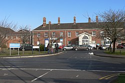
Llandough otherwise Llandough juxta Cardiff is a village and parish in Glamorgan to the north-west of Penarth. It overlooks Cardiff, Penarth and the Bristol Channel. Llandough Hospital is one of largest hospitals in the Cardiff area.
History
Excavations have shown that the village's history goes back as far as the Roman occupation. The site of a Roman villa was found during excavations of a neighbouring farm in the 1990s.
Llandough was long believed to be one of the main ecclesiastical centres in south east Wales, and was almost certainly the site of St Dochwy's monastery. Evidence to support this claim was found when the excavations of the Roman villa revealed post-Roman burials, and also during another excavation in 1994, when the remains of over 800 individual burials, all dating from the 4th century to the 12th century AD were revealed.
However, this monastery no longer exists. It was perhaps overshadowed by the ecclesiastical site at Llandaff, and reduced to the importance of a parish church. The current church, which was built in the middle of the 19th century by the Llandaff diocesan architects, Prichard and Seddon, replaced one built a few years earlier, which was apparently sold to the next village of Leckwith, and moved piece-by-piece to be erected there. A 10th- or 11th-century stone cross, with the incised name Irbic, stands in the churchyard at Llandough.
To the west of the church are three fragmentary components of a well-fortified house dating from the 1420s or 1430s,[2] believed to have been built by John de Van.
Until the mid-1960s, Llandough was a small farming and quarrying village but experienced an expansion involving the building of a large number of houses, a primary school and a block of six shopping units. However, these shops have now been demolished.
There were around six thatched cottages in the village around 1960, but only one remained in 2006. Apart from the church and the old "Dame School" (at the junction of Penlan Road and Lewis Road), the only other building of any interest is the "Baron's Court," near the roundabout at the top of Penarth hill. It is the oldest building in the Llandough area, but is now used as a pub restaurant and much hemmed in by a flyover.
Outside links
- Llandough Community Council Website
- Excavations at Llandough Monastery
- The Llandough Girdle
- Llandough Early Mediaeval Cemetery
- Genuki Llandough Resources
- The Early Medieval Monastic Cemetery at Llandough, Glamorgan
- www.geograph.co.uk : photos of Llandough and surrounding area
References
- ↑ "Community and Ward population 2011". https://neighbourhood.statistics.gov.uk/dissemination/LeadKeyFigures.do?a=7&b=11125831&c=CF64+2PA&d=16&e=62&g=6494396&i=1001x1003x1032x1004&m=0&r=0&s=1428591098000&enc=1. Retrieved 9 April 2015.
- ↑ Newman, John (1995). Glamorgan. London: Penguin Group. p. 377. ISBN 0-14-071056-6.