Tongland: Difference between revisions
No edit summary |
mNo edit summary |
||
| (One intermediate revision by one other user not shown) | |||
| Line 2: | Line 2: | ||
|name=Tongland | |name=Tongland | ||
|county=Kirkcudbrightshire | |county=Kirkcudbrightshire | ||
|picture=Tongland Bridge August 2013. | |picture=Tongland Bridge August 2013.jpg | ||
|picture caption=Bridge over the River Dee at Tongland | |picture caption=Bridge over the River Dee at Tongland | ||
|os grid ref=NX697539 | |os grid ref=NX697539 | ||
| Line 10: | Line 10: | ||
|LG district=Dumfries and Galloway | |LG district=Dumfries and Galloway | ||
}} | }} | ||
'''Tongland''' is a small village in [[Kirkcudbrightshire]] about two miles north of the county town, [[Kirkcudbright]]. | '''Tongland''' is a small village and parish in [[Kirkcudbrightshire]] about two miles north of the county town, [[Kirkcudbright]]. | ||
The village stands on the west bank of the [[River Dee, Kirkcudbrightshire|Dee]], in the tong between the Dee and the [[Tarff Water]]. Above the village is the fair ribbon of [[Togland Loch]] into which the Dee opens its course for several miles narrowing to a river again at Tongland but briefly, for below the village the Dee becomes tidal and opens into a modest estuary head. The [[Tarff Water]] is west of the village, and flows south into the Dee estuary here. | The village stands on the west bank of the [[River Dee, Kirkcudbrightshire|Dee]], in the tong between the Dee and the [[Tarff Water]]. Above the village is the fair ribbon of [[Togland Loch]] into which the Dee opens its course for several miles narrowing to a river again at Tongland but briefly, for below the village the Dee becomes tidal and opens into a modest estuary head. The [[Tarff Water]] is west of the village, and flows south into the Dee estuary here. | ||
Latest revision as of 22:53, 8 February 2016
| Tongland | |
| Kirkcudbrightshire | |
|---|---|
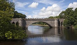
 Bridge over the River Dee at Tongland | |
| Location | |
| Grid reference: | NX697539 |
| Location: | 54°51’47"N, 4°1’53"W |
| Data | |
| Postcode: | DG6 |
| Local Government | |
| Council: | Dumfries and Galloway |
Tongland is a small village and parish in Kirkcudbrightshire about two miles north of the county town, Kirkcudbright.
The village stands on the west bank of the Dee, in the tong between the Dee and the Tarff Water. Above the village is the fair ribbon of Togland Loch into which the Dee opens its course for several miles narrowing to a river again at Tongland but briefly, for below the village the Dee becomes tidal and opens into a modest estuary head. The Tarff Water is west of the village, and flows south into the Dee estuary here.

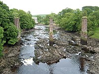
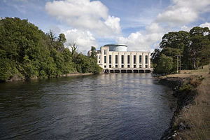
Though a peaceful place of fields, and a golf course, there is the hand of industry too; the power station at the mouth of the river, a quarry by the loch and the pillars of an otherwise vanished railway bridge still striding over the river.
History
Tongland Abbey, a mediæval Premonstratensian monastic community, existed here during the Middle Ages. The remains of this may still be seen together with a church, which is in a state of disrepair. The Dee is crossed shortly downriver by Tongland Bridge, a stone arch bridge constructed in 1806 by Thomas Telford.

Between 1921 and 1922 'Galloway' cars were made in Tongland in a First World War factory. Since the 1930s, Tongland has been the site of a hydro-electric power station, part of the Galloway Hydro Electric Scheme. The station is open to visitors during the summer months. Slightly earlier,
Since 2004, there have been several construction projects, with the site of a former garage now home to two new houses. There are also several more houses being constructed. In 2006, street lights were installed along the A711 which passes through the village.
Outside links
| ("Wikimedia Commons" has material about Tongland) |
