Kiltarlity and Convinth: Difference between revisions
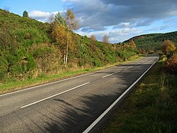
Created page with "{{county|Inverness-shire}} thumb|250px|right|Glen Convinth from the A833 '''Kiltarlity and Convinth''' is a parish in nor..." |
m clean up, typos fixed: and and → and |
||
| (One intermediate revision by one other user not shown) | |||
| Line 1: | Line 1: | ||
{{county|Inverness-shire}} | {{county|Inverness-shire}} | ||
[[File:Glen Convinth - geograph.org.uk - 274353.jpg|thumb|250px|right|Glen Convinth from the A833]] | [[File:Glen Convinth - geograph.org.uk - 274353.jpg|thumb|250px|right|Glen Convinth from the A833]] | ||
'''Kiltarlity and Convinth''' is a parish in northern [[Inverness-shire]] corresponding to the ancient parish of Convinth, from which Kiltarlity was formed in 1226. Bounded to the north-west and north by [[Kilmorack]], east by [[Kirkhill, Inverness-shire|Kirkhill]] and [[Inverness]], and south by [[Urquhart and Glenmoriston]], it has an utmost length from north-east to south-west of 30¼ miles and a varying width of between ½ mile | '''Kiltarlity and Convinth''' is a parish in northern [[Inverness-shire]] corresponding to the ancient parish of Convinth, from which Kiltarlity was formed in 1226. Bounded to the north-west and north by [[Kilmorack]], east by [[Kirkhill, Inverness-shire|Kirkhill]] and [[Inverness]], and south by [[Urquhart and Glenmoriston]], it has an utmost length from north-east to south-west of 30¼ miles and a varying width of between ½ mile and 10 miles. | ||
Besides Kiltarlity, the parish also includes the villages and hamlets of Blachraggan, Culburnie, Camault Muir and Tomich as well as [[Erchless Castle]]. | Besides Kiltarlity, the parish also includes the villages and hamlets of Blachraggan, Culburnie, Camault Muir and [[Tomich]] as well as [[Erchless Castle]]. | ||
==Mountains and hills== | ==Mountains and hills== | ||
Latest revision as of 19:01, 27 January 2016

Kiltarlity and Convinth is a parish in northern Inverness-shire corresponding to the ancient parish of Convinth, from which Kiltarlity was formed in 1226. Bounded to the north-west and north by Kilmorack, east by Kirkhill and Inverness, and south by Urquhart and Glenmoriston, it has an utmost length from north-east to south-west of 30¼ miles and a varying width of between ½ mile and 10 miles.
Besides Kiltarlity, the parish also includes the villages and hamlets of Blachraggan, Culburnie, Camault Muir and Tomich as well as Erchless Castle.
Mountains and hills
Almost everywhere hilly or mountainous, the surface in the extreme north-east is only 18 feet above sea-level but it rises to:
- Tor Mor (487 feet)
- Meall Mor (1,316)
- Creag Ard Mhor (933)
- the eastern shoulder (2,032)* of Carn nam Pollan
- Carn nam Bad (1,499)*
- Clach-bheinn (1,887)
- Carn a' Choire Chruaidh (2,830)
- Carn a' Choire Chairbh (2,827)*
where asterisks mark those summits on the borders of the parish.
This Inverness-shire article is a stub: help to improve Wikishire by building it up.