Barnes: Difference between revisions
Jump to navigation
Jump to search
Created page with '{{Infobox town |name=Barnes |county=Surrey |picture=BarnesPond693-4.JPG |picture caption=Barnes Pond |os grid ref=TQ225765 |latitude=51.4741 |longitude=-0.2352 |post town=London …' |
|||
| (One intermediate revision by the same user not shown) | |||
| Line 23: | Line 23: | ||
{{stub|Surrey}} | {{stub|Surrey}} | ||
[[Category:Metropolitan Surrey]] | |||
Latest revision as of 10:53, 25 January 2016
| Barnes | |
| Surrey | |
|---|---|
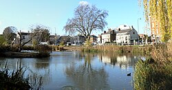
 Barnes Pond | |
| Location | |
| Grid reference: | TQ225765 |
| Location: | 51°28’27"N, 0°14’7"W |
| Data | |
| Post town: | London |
| Postcode: | SW13 |
| Dialling code: | 020 |
| Local Government | |
| Council: | Richmond upon Thames |
| Parliamentary constituency: |
Richmond Park |
Barnes is a town of Surrey now deep within the metropolitan conurbation but retaining its own identity. It stands on the south bank of the River Thames, in a loop of the river bounded by Hammersmith Bridge at the north end. Opposite it on the Middlesex bank lies Chiswick.
The Thames here forms meadows which have been converted into wetlands for the support of wildlife, known as the London Wetlands Centre.
Barnes has a number of 18th and 19th century buildings of exceptional quality, and is often noted for its historic village area centred on the pond, forming the Barnes Village conservation area.
References

This Surrey article is a stub: help to improve Wikishire by building it up.