Mylor Bridge: Difference between revisions
Jump to navigation
Jump to search
Created page with "{{Infobox town |county=Cornwall |name=Mylor Bridge |cornish=Ponsnowyth |picture=Mylor Bridge - geograph.org.uk - 199047.jpg| |picture caption=Mylor Bridge |os grid ref=SW80436..." |
mNo edit summary |
||
| Line 1: | Line 1: | ||
{{Infobox town | {{Infobox town | ||
|name=Mylor Bridge | |name=Mylor Bridge | ||
|cornish=Ponsnowyth | |cornish=Ponsnowyth | ||
|picture=Mylor | |county=Cornwall | ||
|picture caption=Mylor | |picture=Mylor Quay - at spring tide - geograph.org.uk - 459039.jpg | ||
|picture caption=Mylor Quay | |||
|os grid ref=SW804363 | |os grid ref=SW804363 | ||
|latitude=50.186 | |latitude=50.186 | ||
Latest revision as of 21:27, 29 October 2015
| Mylor Bridge Cornish: Ponsnowyth | |
| Cornwall | |
|---|---|
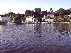
 Mylor Quay | |
| Location | |
| Grid reference: | SW804363 |
| Location: | 50°11’10"N, 5°4’41"W |
| Data | |
| Post town: | Falmouth |
| Postcode: | TR11 |
| Dialling code: | 01326 |
| Local Government | |
| Council: | Cornwall |
| Parliamentary constituency: |
Truro and Falmouth |
Mylor Bridge is a village in Cornwall, standing at the head of Mylor Creek, about five miles north of Falmouth.
Mylor Bridge has a post office, newsagent, grocery store, fishmonger, butcher's shop and a pub called the Lemon Arms. The village also has a primary school.[1] The parish church of Saint Mylor is in the nearby village of Mylor Churchtown.[2]
Mylor Bridge is within the Cornwall Area of Outstanding Natural Beauty, as does almost a third of the county.
The village has a King George V Playing Field.
References
- ↑ Mylor Bridge Primary School; Retrieved April 2010
- ↑ GENUKI website; Mylor. Retrieved April 2010