Sker Point: Difference between revisions
Jump to navigation
Jump to search
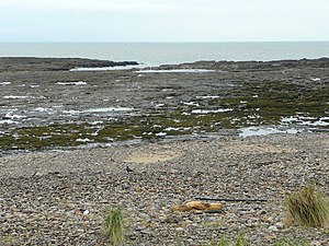
Created page with "thumb|Sker Point, with the inlet of Pwll Dafan '''Sker Point''' is a headland on the Glamorgan coast between Port Tal..." |
No edit summary |
||
| Line 1: | Line 1: | ||
{{county|Glamorgan}} | |||
[[File:Pwll Dafan - geograph.org.uk - 1006077.jpg|thumb|Sker Point, with the inlet of Pwll Dafan]] | [[File:Pwll Dafan - geograph.org.uk - 1006077.jpg|thumb|Sker Point, with the inlet of Pwll Dafan]] | ||
'''Sker Point''' is a headland on the [[Glamorgan]] coast between [[Port Talbot]] and [[Porthcawl]]. It marks the south end of Kenfig Sands. | '''Sker Point''' is a headland on the [[Glamorgan]] coast between [[Port Talbot]] and [[Porthcawl]]. It marks the south end of Kenfig Sands. | ||
Latest revision as of 13:51, 12 December 2014

Sker Point is a headland on the Glamorgan coast between Port Talbot and Porthcawl. It marks the south end of Kenfig Sands.
On April 23, 1947 the Samtampa, a liberty ship, was wrecked at Sker Point. Her crew of 39 perished and all eight volunteer crewmen of the Mumbles RNLI lifeboat were lost while attempting to rescue them. There is a memorial plaque set into the rocks of Sker Point.[1]
References
- ↑ Kenfig.org.uk Local History resource Accessed 28 October 2013