Resolis: Difference between revisions
Jump to navigation
Jump to search
Created page with "{{Infobox town |name=Resolis |county=Cromartyshire |picture= |os grid ref=NH667651 |latitude=57.656871 |longitude=-4.235003 |population= |census year= |post town= |postcode=IV..." |
mNo edit summary |
||
| (2 intermediate revisions by 2 users not shown) | |||
| Line 2: | Line 2: | ||
|name=Resolis | |name=Resolis | ||
|county=Cromartyshire | |county=Cromartyshire | ||
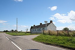
|picture= | |picture=The Resolis Mains Junction on the A9163. - geograph.org.uk - 207437.jpg | ||
|picture caption=The Resolis Mains Junction | |||
|os grid ref=NH667651 | |os grid ref=NH667651 | ||
|latitude=57.656871 | |latitude=57.656871 | ||
| Line 8: | Line 9: | ||
|population= | |population= | ||
|census year= | |census year= | ||
|post town= | |post town=Dingwall | ||
|postcode=IV7 | |postcode=IV7 | ||
|dialling code= | |dialling code=01349/01381 | ||
|LG district=Highland | |LG district=Highland | ||
|constituency= | |constituency= | ||
| Line 20: | Line 21: | ||
'''Newmills''' is the hamlet south of the road where stands the parish kirk of Resolis. | '''Newmills''' is the hamlet south of the road where stands the parish kirk of Resolis. | ||
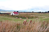
'''Alnessferry''' and '''Ferryton''' are two | [[File:Alnessferry (Cromartyshire) abandoned cottage - geograph-2008374-by-Steven-Brown.jpg|left|thumb|200px|Cottage at Alnessferry]] | ||
'''Alnessferry''' and '''Ferryton''' are two hamlets north of the road, on the [[Cromarty Firth]] opposite the [[Ross-shire]] village of [[Alness]], though no ferry runs between them today. | |||
Weestward the road cross the Bog of Cullicudden and eastward to [[Balblair]] (an isolated part of [[Ross-shire]]). | Weestward the road cross the Bog of [[Cullicudden]] and eastward to [[Balblair]] (an isolated part of [[Ross-shire]]). | ||
Latest revision as of 10:09, 4 December 2014
| Resolis | |
| Cromartyshire | |
|---|---|
 The Resolis Mains Junction | |
| Location | |
| Grid reference: | NH667651 |
| Location: | 57°39’25"N, 4°14’6"W |
| Data | |
| Post town: | Dingwall |
| Postcode: | IV7 |
| Dialling code: | 01349/01381 |
| Local Government | |
| Council: | Highland |
Resolis is a hamlet and parish in Cromartyshire, in the "old shire"; the original Cromartyshire deemed to be the main body of the county on the Black Isle.
The parish is one of scattered hamlets, along the B9163 that runs up the Black Isle, and amongst the meadows either side. Resolis itself is generally used for the cottages strung along the road.
Newmills is the hamlet south of the road where stands the parish kirk of Resolis.

Alnessferry and Ferryton are two hamlets north of the road, on the Cromarty Firth opposite the Ross-shire village of Alness, though no ferry runs between them today.
Weestward the road cross the Bog of Cullicudden and eastward to Balblair (an isolated part of Ross-shire).