Ambleside: Difference between revisions
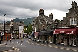
Created page with '{{Infobox town |name= Ambleside |county = Westmorland |picture= Rydal Rd, Ambleside, Cumbria - June 2009.jpg |picture caption= Rydal Road, Ambleside Town Centre |os grid ref= NY3…' |
|||
| (One intermediate revision by one other user not shown) | |||
| Line 35: | Line 35: | ||
==Buildings== | ==Buildings== | ||
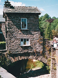
[[File: | [[File:Ambleside Town Centre.jpg|right|thumb|200px|Bridge House, Ambleside]] | ||
* '''Bridge House''' was built over Stock Ghyll more than 300 years ago probably as a summer house and apple store for Ambleside Hall. The building was purchased by local people in 1926 and given to the [[National Trust for Places of Historic Interest or Natural Beauty|National Trust]]. It is now used as an information centre for the National Trust, and is part of the Trust's [[Windermere and Troutbeck]] property.<ref>Bridge House — Information from a notice at Bridge House.</ref> | * '''Bridge House''' was built over Stock Ghyll more than 300 years ago probably as a summer house and apple store for Ambleside Hall. The building was purchased by local people in 1926 and given to the [[National Trust for Places of Historic Interest or Natural Beauty|National Trust]]. It is now used as an information centre for the National Trust, and is part of the Trust's [[Windermere and Troutbeck]] property.<ref>Bridge House — Information from a notice at Bridge House.</ref> | ||
* '''William Wordsworth's house''' at [[Rydal Mount]] stands near the town. | * '''William Wordsworth's house''' at [[Rydal Mount]] stands near the town. | ||
| Line 56: | Line 56: | ||
*[http://www.english-lakes.com/ambleside.html Illustrated guide to Ambleside] | *[http://www.english-lakes.com/ambleside.html Illustrated guide to Ambleside] | ||
*[http://www.amblesideprimary.com Ambleside Primary School] The multi-award winning school website has many sections devoted to local history and geography and the Lake District | *[http://www.amblesideprimary.com Ambleside Primary School] The multi-award winning school website has many sections devoted to local history and geography and the Lake District | ||
*[http://www.amblesidecumbria.co.uk/gallery/c1.html Ambleside Photographs] On the Ambleside | *[http://www.amblesidecumbria.co.uk/gallery/c1.html Ambleside Photographs] On the Ambleside website. | ||
*[http://www.windermere-way.co.uk/ The Windermere Way - a walking route that goes right around the lake.] | *[http://www.windermere-way.co.uk/ The Windermere Way - a walking route that goes right around the lake.] | ||
*[http://www.visitcumbria.com/amb/galava.htm VisitCumbria.com - Galava Roman Fort] | *[http://www.visitcumbria.com/amb/galava.htm VisitCumbria.com - Galava Roman Fort] | ||
*[http://www.golakes.co.uk/places/towns/ambleside-history.aspx Golakes.co.uk - Ambleside sense of place history page] | *[http://www.golakes.co.uk/places/towns/ambleside-history.aspx Golakes.co.uk - Ambleside sense of place history page] | ||
*[http://www.youtube.com/watch?v=M_2ZJ2gb73c Stock Ghyll Force] A film of the waterfall above Ambleside during the November 2009 flooding | *[http://www.youtube.com/watch?v=M_2ZJ2gb73c Stock Ghyll Force] A film of the waterfall above Ambleside during the November 2009 flooding. | ||
*[http://www.allaboutambleside.co.uk All About Ambleside] | *[http://www.allaboutambleside.co.uk All About Ambleside] | ||
Latest revision as of 21:51, 5 September 2014
| Ambleside | |
| Westmorland | |
|---|---|
 Rydal Road, Ambleside Town Centre | |
| Location | |
| Grid reference: | NY375037 |
| Location: | 54°25’31"N, 2°57’45"W |
| Data | |
| Population: | 2,600 |
| Post town: | Ambleside |
| Postcode: | LA22 |
| Dialling code: | 015394 |
| Local Government | |
| Council: | Westmorland & Furness |
| Parliamentary constituency: |
Westmorland and Lonsdale |
Ambleside is a town in Westmorland, which stands at the head of Windermere, England's largest lake. The town is within the Lake District National Park and is a centre for fell-walking and sightseeing.
From Ambleside the Kirkstone Road leads north up through the dramatic Kirkstone Pass linking Windermere with Ullswater over the high fells.
The town and around
The name of Ambleside appears to come from Old Norse, perhaps Hamles sǽtr ("Hamel's summer pasture") or Á-mel-sǽtr ("riverbank pasture").
Boats run along the lake from Ambleside to Bowness-on-Windermere and Lakeside, offering fine views of the lake and surrounding mountains. Ambleside is a base for hiking, mountaineering and mountain biking. It has a selection of shops, hotels, guest houses, pubs and restaurants.
To the south of Ambleside is the Roman fort of Galava, dating from 79 AD.[1]
The Armitt Library and Museum provides a source of local history with a collection which represents many of the local artists and writers of the past.
On the west, Loughrigg Fell rises above the town; to the north are Red Screes and the hills of the Fairfield group. To the east is Wansfell.
History
Ambleside was granted a market charter in 1650[2], and its Market Place became the commercial centre for agriculture and the wool trade. King James II granted a further charter allowing the town to collect tolls.[3]
The old packhorse trail between Ambleside and Grasmere was the main route between the two towns before the new turnpike road was completed in 1770. Smithy Brow at the end of the trail was where packponies were re-shod after their journey. With the coming of the turnpikes, the packhorse trains were superseded by horse-drawn stagecoaches, which regularly travelled between Keswick and Kendal by way of Ambleside[4].
Buildings

- Bridge House was built over Stock Ghyll more than 300 years ago probably as a summer house and apple store for Ambleside Hall. The building was purchased by local people in 1926 and given to the National Trust. It is now used as an information centre for the National Trust, and is part of the Trust's Windermere and Troutbeck property.[5]
- William Wordsworth's house at Rydal Mount stands near the town.
- The Homes of Football photographic art gallery on Lake Road houses the work of the photographer Stuart Roy Clarke, and represents one of the best collections of football photography in the world.
Mountain rescue
The town maintains one of the busiest volunteer mountain rescue teams Langdale and Ambleside MRT in Great Britain.
References
- ↑ http://www.visitcumbria.com/amb/galava.htm Retrieved on 2008-02-07
- ↑ http://www.amblesideonline.co.uk/history.shtml
- ↑ www.lakedistricts.co.uk/ambleside
- ↑ "History of Ambleside". Golakes. http://www.golakes.co.uk/places/towns/ambleside-history.aspx. Retrieved 2010-06-24.
- ↑ Bridge House — Information from a notice at Bridge House.
Outside links
- Windermere and Troutbeck (including Bridge House) information at the National Trust
- Village Centre Hotel and Spa
- Armitt Library
- St Martin's College
- The Cumbria Directory - Ambleside
- Illustrated guide to Ambleside
- Ambleside Primary School The multi-award winning school website has many sections devoted to local history and geography and the Lake District
- Ambleside Photographs On the Ambleside website.
- The Windermere Way - a walking route that goes right around the lake.
- VisitCumbria.com - Galava Roman Fort
- Golakes.co.uk - Ambleside sense of place history page
- Stock Ghyll Force A film of the waterfall above Ambleside during the November 2009 flooding.
- All About Ambleside
