Allander Water: Difference between revisions
Jump to navigation
Jump to search
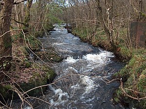
Created page with "right|thumb|300px|The Allander Water in Mugdock Wood {{county|Stirlingshire}} The '''Allande..." |
No edit summary |
||
| Line 4: | Line 4: | ||
The Allander Water rises in a number of streams off the [[Kilpatrick Hills]] and flows southeastwards forming the border between [[Dunbartonshire]] to the west and [[Stirlingshire]] to the east. At [[Milngavie]] it fully enters [[Stirlingshire]], and soon reaches the River Kelvin. | The Allander Water rises in a number of streams off the [[Kilpatrick Hills]] and flows southeastwards forming the border between [[Dunbartonshire]] to the west and [[Stirlingshire]] to the east. At [[Milngavie]] it fully enters [[Stirlingshire]], and soon reaches the River Kelvin. | ||
A Roman fort of the [[Antonine Wall]] can be found south of this meeting of the waters. | |||
==Outside links== | ==Outside links== | ||
Latest revision as of 23:13, 9 June 2014

The Allander Water is a river which forms part of the boundary between Dunbartonshire and Stirlingshire, and which one of the three main tributaries of the River Kelvin, the others being the Glazert Water and the Luggie Water.
The Allander Water rises in a number of streams off the Kilpatrick Hills and flows southeastwards forming the border between Dunbartonshire to the west and Stirlingshire to the east. At Milngavie it fully enters Stirlingshire, and soon reaches the River Kelvin.
A Roman fort of the Antonine Wall can be found south of this meeting of the waters.