Aisholt: Difference between revisions
Jump to navigation
Jump to search
Created page with '{{Infobox town |name=Aisholt |county=Somerset |picture= |os grid ref=ST194355 |latitude=51.113517 |longitude=-3.151747 |population= |census year= |post town= |postcode=TA5 |diall…' |
mNo edit summary |
||
| Line 2: | Line 2: | ||
|name=Aisholt | |name=Aisholt | ||
|county=Somerset | |county=Somerset | ||
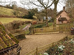
|picture= | |picture=Cottage near Aisholt - geograph.org.uk - 1187772.jpg | ||
|os grid ref=ST194355 | |os grid ref=ST194355 | ||
|latitude=51.113517 | |latitude=51.113517 | ||
Latest revision as of 21:27, 9 November 2012
| Aisholt | |
| Somerset | |
|---|---|

| |
| Location | |
| Grid reference: | ST194355 |
| Location: | 51°6’49"N, 3°9’6"W |
| Data | |
| Postcode: | TA5 |
| Local Government | |
Aisholt is a tiny Somerset village, nestled in the Quantock Hills. It is gathered around its church, thatched cottages surrounded by woodland and pasture.
The parish church is All Saints, a modest church with a high, crenulated tower, the central highlight of a very pretty village.
Aisholt is one of the Thankful Villages, those few places which were so blessed as to received back without loss all the men who went to the Great War of 1914-1918.

This Somerset article is a stub: help to improve Wikishire by building it up.