Tonypandy: Difference between revisions
Created page with '{{Infobox town |name=Tonypandy |county=Glamorgan |picture=Tonypandy Square in 2007.jpg |picture caption=Tonypandy Square |os grid ref=SS995925 |latitude=51.622325 |longitude=-3.4…' |
m →Books |
||
| Line 36: | Line 36: | ||
==Books== | ==Books== | ||
* | *Davis, Paul R: ''Historic Rhondda'' (1989, Hackman) | ||
[[Category:Rhondda Valley]] | [[Category:Rhondda Valley]] | ||
Latest revision as of 20:02, 7 October 2012
| Tonypandy | |
| Glamorgan | |
|---|---|
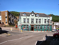
 Tonypandy Square | |
| Location | |
| Grid reference: | SS995925 |
| Location: | 51°37’20"N, 3°27’4"W |
| Data | |
| Population: | 3,495 (2001) |
| Post town: | Tonypandy |
| Postcode: | CF40 |
| Dialling code: | 01443 |
| Local Government | |
| Council: | Rhondda Cynon Taf |
| Parliamentary constituency: |
Rhondda |
Tonypandy is a town in Glamorgan, within the Rhondda Fawr Valley. A former industrial coal mining town, today Tonypandy is also known less pleasantly as the site of the Tonypandy Riots.
The town is served by Tonypandy railway station.
George Thomas, a former Speaker of the House of Commons, was educated at Tonypandy Secondary Grammar School. At his retirement he was elevated to the peerage as 1st Viscount Tonypandy.
History
Pre-industrial history
The Tonypandy area contains several prehistoric sites, the main one being Mynydd y Gelli. Located to the north-west of the town, the remains of an Iron Age settlement Hen Dre'r Gelli lies on the slopes of Mynydd Y Gelli hill between Tonypandy and Gelli. Near the same location are several Bronze Age cairns.[1]
Tonypandy is also the site of one of the only two permanent Middle Ages fortifications found within the Rhondda Valley. Named Ynysygrug, it was a lesser motte and bailey earthwork defence. The fortification appears to have consisted of a wooden tower surrounded by a small fortified courtyard.[2] Placed around the 12th or early 13th century, the remains of the fortification were mostly destroyed when the town's railway was constructed in the 19th century. Over the past two hundred years, the fortification had been wrongly thought to be the burial place of Rhys ap Tewdwr or a prehistoric worship site.[2]
The regional library service recounts that the name 'Tonypandy' means the meadow of the fulling mill which was established there in 1838. "E. D. Lewis in his work The Rhondda Valleys provides us with an outline history of the mill that once stood in Tonypandy, and from which the town took its name".[3]
Industrial era
In the mid-19th century, the Rhondda began its industrial transformation after the successful excavation of coal. With the extension of the Taff Vale Railway to Treherbert and Maerdy in 1856, the Rhondda grew as property speculators switched their interests from farming to developing mining communities. Tonypandy, unlike the surrounding villages, grew as a financial and social hub, providing services and amenities for the neighbouring communities.
References
- ↑ Davis (1989), pg 14.
- ↑ Jump up to: 2.0 2.1 Davis (1989), pg 26.
- ↑ Heritage trail (Tonypandy) Rhondda Cynon Taf Library Service
Books
- Davis, Paul R: Historic Rhondda (1989, Hackman)