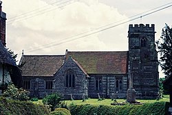
Witchampton
| Witchampton | |
| Dorset | |
|---|---|
 St Mary, St Cuthburga & All Saints, Witchampton | |
| Location | |
| Grid reference: | ST988064 |
| Location: | 50°51’25"N, 2°1’5"W |
| Data | |
| Population: | 398 |
| Post town: | Wimborne |
| Postcode: | BH21 |
| Dialling code: | 01258 |
| Local Government | |
| Council: | Dorset |
| Parliamentary constituency: |
North Dorset |
Witchampton is a village in eastern Dorset, on the River Allen five miles north of Wimborne Minster. The 2011 census records a population of 398.
Witchampton lies close to where the dip slope of the chalk hills of Cranborne Chase is overlain by newer deposits of London clay. Although Witchampton is sited within the area of the chalk, where cob and thatch are the traditional building materials, the nearness of the clay has resulted in many of the older houses in the village being built from brick.[1] The early 16th-century Abbey House contains some of the earliest brickwork in the county.[2]
To the north-east of the village there used to be a paper mill by the river. In 1980 it was described by writer Roland Gant as a "discreet industrial oasis in an agricultural plain".[3] It had been in operation since the early 18th century, but has now been converted to residential accommodation.[2]
11th-century whalebone chess pieces have been found within the parish, and are some of the best surviving early chess pieces in the country.[4]
Outside links
| ("Wikimedia Commons" has material about Witchampton) |
References
- ↑ Ralph Wightman (1983). Portrait of Dorset (4 ed.). Robert Hale Ltd. pp. 63–64. ISBN 0 7090 0844 9.
- ↑ 2.0 2.1 Clive Hannay (September 2012). "Witchampton: Short walk with Clive Hannay". Dorset Life. http://www.dorsetlife.co.uk/2012/09/witchampton-short-walk-with-clive-hannay/. Retrieved 24 May 2013.
- ↑ Roland Gant (1980). Dorset Villages. Robert Hale Ltd. pp. 34–5. ISBN 0 7091 8135 3.
- ↑ Chessays - When There is no End to a Good Game