Wambrook
Jump to navigation
Jump to search
| Wambrook | |
| Dorset | |
|---|---|
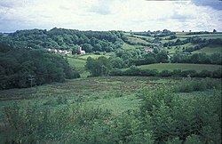
 Wambrook, seen from the west | |
| Location | |
| Grid reference: | ST295075 |
| Location: | 50°51’45"N, 3°0’11"W |
| Data | |
| Population: | 184 (2011[1]) |
| Post town: | Chard |
| Postcode: | TA20 |
| Dialling code: | 01460 |
| Local Government | |
| Council: | South Somerset |
| Parliamentary constituency: |
Yeovil |
Wambrook is a village and parish in a salient of Dorset between Somerset to the north and east; and Devon to the west. Sitting in the Blackdown Hills it is two miles south of Chard in Somerset. The parish includes the hamlets of Higher Wambrook and Lower Wambrook, sometimes known as Haselcombe.
History
In the west of the parish at Wortheal there are substantial earthworks which may date from the Iron Age.[2]
Notable people
- Samuel Vickery, recipient of the Victoria Cross.
Religious sites
The Church of St Mary dates from the 13th century and has been designated by English Heritage as a Grade II* listed building.[3] In the churchyard are a 17th-century set of stocks.[4]
References
- ↑ "Statistics for Wards, LSOAs and Parishes — SUMMARY Profiles" (Excel). Somerset Intelligence. http://www.somersetintelligence.org.uk/files/Somerset%20Census%20Key%20Statistics%20-%20Summary%20Profiles.xls. Retrieved 4 January 2014.
- ↑ Bush, Robin (1994). Somerset: The Complete Guide. Dovecote Press. pp. 212. ISBN 1-874336-26-1.
- ↑ "Church of St Mary". Images of England. http://www.imagesofengland.org.uk/details/default.aspx?id=431569. Retrieved 2008-02-03.
- ↑ "Stocks set against north wall of tower, Church of St Mary". Images of England. English Heritage. http://www.imagesofengland.org.uk/Details/Default.aspx?id=431570. Retrieved 2009-02-08.
| ("Wikimedia Commons" has material about Wambrook) |