Togher, County Cork
| Togher Irish: An Tochar | |
| County Cork | |
|---|---|
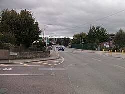
 Togher Road in Togher | |
| Location | |
| Grid reference: | W662697 |
| Location: | 51°52’45"N, 8°29’31"W |
| Data | |
| Population: | 2,765 (2016) |
| Local Government | |
| Council: | Cork |
| Dáil constituency: |
Cork South-Central |
Togher is a suburb on the southside of Cork city, in County Cork.
The name of the place is from the Irish An Tóchar, meaning 'The causeway or level place'[1]
Geography
Togher is bounded to the north by The Lough, to the south by Ballincrannig and Farmers Cross, to the east by Ballyphehane and to the west by Waterfall and Wilton.[2] Flowing through the parish is the Liberty Stream, from Corcoran's Bridge to Togher Cross where it disappears underground for a short while before re-emerging at Greenwood and joining the larger Tramore River on its way to Douglas.[2]
History
Historically Togher was an agricultural area with large estates owned by Ascendancy families such as the Sarsfields.[2] Togher originally lay in the parish of St Finbarr's South until 1890, when it formed part of the newly created parish of St Finbarr's West, better known as the Lough Parish. Togher's Roman Catholic church, the 'Church of the Way of the Cross', was built in 1972 to "meet the needs of the growing suburban population".[3]
Sport
- Gaelic sports: St Finbarr's National Hurling & Football Club<ref>St Finbarrs National Hurling and Football Club
References
- ↑ An Tóchar / Togher: Placenames Database of Ireland
- ↑ 2.0 2.1 2.2 "Take a stroll and discover Togher". Cork Independent. 1 September 2016. http://www.corkindependent.com/features/aroundthecounty/articles/2016/09/01/4125933-take-a-stroll-and-discover-togher/.
- ↑ "Church of the Way of the Cross, Togher Road, Togher, Cork". National Inventory or Architectural Heritage. http://www.buildingsofireland.ie/niah/search.jsp?type=record&county=CO®no=20870007.