Sutton-cum-Lound
| Sutton cum Lound | |
| Nottinghamshire | |
|---|---|
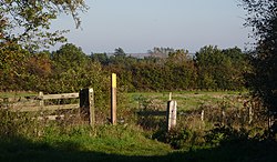
 Footpath to Sutton cum Lound | |
| Location | |
| Grid reference: | SK681847 |
| Location: | 53°21’0"N, -0°58’48"W |
| Data | |
| Population: | 673 (2011) |
| Post town: | Retforrd |
| Postcode: | DN22 |
| Dialling code: | 01777 |
| Local Government | |
| Council: | Bassetlaw |
| Parliamentary constituency: |
Bassetlaw |
Sutton-Cum-Lound is a village in northern Nottinghamshire, thee miles from Retford. The population of the civil parish of 'Sutton' according to the 2011 census was 673.

The parish church, St Bartholomew is a Norman edifice, rebuilt later in the Perpendicular style, with 'unbridled curvilinear tracery' in the chancel windows.[1]
The village has a primary school. It borders the village of Barnby Moor which is about a mile away and is also very close to the village of Lound. The village has a number of public footpaths and walks such as those on Mire Hill.
The village sometimes has traffic problems caused by the Level crossing on Station Road which leads to Barnby Moor, The crossing goes over the East Coast Main Line which is a very busy railway line. However, there are three entrances to the village in total.
The village is also very close to Wetlands Wildlife Park near Lound and many of its fishing lakes as well as the Idle Valley Nature Reserve wetlands Site of Special Scientific Interest to the east of the village within walking distance.
Outside links
| ("Wikimedia Commons" has material about Sutton-cum-Lound) |
References
- ↑ Nikolaus Pevsner: The Buildings of England: Nottinghamshire, 1951; 1979 Penguin Books ISBN 978-0-300-09636-1page 343