Stanton-on-the-Wolds
| Stanton-on-the-Wolds | |
| Nottinghamshire | |
|---|---|
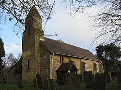
 All Saints, Stanton-on-the-Wolds | |
| Location | |
| Grid reference: | SK631304 |
| Location: | 52°52’5"N, 1°3’47"W |
| Data | |
| Local Government | |
Stanton-on-the-Wolds is a small village in southern Nottinghamshire, standing about six miles south-east of Nottingham, just off the A606 Nottingham to Melton Mowbray road. It is bordered by several other villages, namely, Clipston-on-the-Wolds, Normanton-on-the-Wolds, Keyworth and Widmerpool.
History
Artefacts from Stanton have been recorded as dating to all three periods of the Stone Age: Paleolithic, Mesolithic and Neolithic.[1] The oldest was a worked flint core found in 2006 after ditch maintenance west of the stream below Hill Farm.[2]
Stanton has had various names: in 1086 it was known as Stanture and as Estanton in 1235. It is recoded as 'Stanton Super Wold' in 1240-80.
According to local history, in the late 18th-century, the village was hit by a freak hailstorm when large stones caused extensive damage and this accounts for the lack of older buildings.[3]
Parish church
The parish church is the Church of All Saints. Originally dedicated to St. John the Baptist, it was re-dedicated during the 19th century, The church is located on Browns Lane in Stanton. It is a small church situated close Stanton golf course.
The church is a part of the Benefice of Keyworth Stanton and Bunny, along with St Mary Magdalene, Keyworth and St Mary the Virgin, Bunny with Bradmore.
About the village
The war memorial was erected in 1920 close to the north-west corner of All Saints Parish Church and was funded by parish subscription. It was made by William Bryans, the Overseer of Stanton for the Bingham Union. The stone cross stands on a plinth that is inscribed with the names of the three men from the parish who fell in First World War. It is a Grade II listed structure.
Water tower
Until the 1930s, most villages south of the River Trent were supplied from Nottingham's reservoirs and water mains. However, from beyond Plumtree railway station the ground levels become higher. To maintain a reliable water supply to the Wolds villages a water tower was erected opposite Stanton Parish Church and a pumping station near Plumtree railway station to pump water to the top of the tower. A spiral structure of 115 steps led to the summit through a shaft in the centre of the tanks. In order to ensure a firm foundation, a borehole was sunk to the depth of 90 feet where a foundation was located. The tower was to be hidden from view from the road by planting a shrubbery and a row of beech trees. 21 poplar trees were planted around the perimeter of the tower itself and there was to be an apple orchard and the site contained within a wrought-iron fence. The opening of Stanton Water Tower was reported in the Nottingham Guardian dated 26 June 1923.
The water tower was demolished in 1985 leaving the surrounding circle of Poplar trees.[4]
Stanton tunnel
Stanton tunnel is the longest of the four tunnels on the Nottingham to Melton Mowbray Railway]] and runs for 1,332 yards. Construction of the line began in 1874, the tunnel was completed in 1878 and the line opened in 1879. The line was closed in 1968, but British Rail retained the line from Melton Mowbray to Edwalton. This is now known as the Old Dalby Test Track.[5]
Stanton-on-the-Wolds Golf Club
The club was established in March 1906 by local residents. The course has 18 holes and was designed by the architect and golfer Tom Williamson.[6]
References
- ↑ Philips (1972). "Stanton Stone Age Artefacts". https://s3-eu-west-1.amazonaws.com/s3.spanglefish.com/s/37541/documents/history/stone-age-stanton.pdf.
- ↑ History: Stanton-on-the-Wolds Parish Council
- ↑ About Stanton: Stanton-on-the-Wolds Parish Council
- ↑ Unknown. "Stanton-on-the-Wolds Water Tower". https://s3-eu-west-1.amazonaws.com/s3.spanglefish.com/s/37541/documents/history/stanton-water-tower.pdf.
- ↑ Stanton Tunnel: Stanton-on-the-Wolds Parish Council
- ↑ Stanton On The Wolds Golf Club