Saint John, Jersey
| Saint John Jèrriais: St Jean | |
| Jersey | |
|---|---|
 Parish hall | |
.svg)
| |
 | |
| Area: | 2,150 acres |
| Population: | 2,618 |
| Island: | Jersey |
Saint John is one of the twelve parishes of Jersey. Saint John is in the north of Jersey and borders St Mary on its west, Trinity to the east, and St Lawrence and Saint Helier on its south.
Largely a rural community, the parish has a good local shopping area (grocer, post office, pharmacy, sandwich/coffee bar, medical surgery, hairdresser and kitchen design shop) around its parish church and parish hall.
The cliffs of the north coast afford some of the best views in Jersey. After Trinity, it has the second highest point in Jersey at Mont Mado (473 feet). The parish covers territory of 4,846 vergées (2,150 acres).
Mont Mado granite was quarried historically. The largest quarry is now that of Ronez on the north coast.

The "Centre Stone" at Sion in St John is traditionally regarded as the centre of the Island although it is far from the geographic centre by modern calculations. The stone is prehistoric, showing evidence of cup marks, and may have been brought from a nearby dolmen now vanished.
La Route du Nord was constructed during the Occupation of the Channel Islands as a scheme to provide work. The road is now dedicated to the men and women of Jersey who suffered 1939-1945.
Vingtaines
The parish is divided into three vingtaines:
The parish is one electoral district and elects one Deputy.
Pictures
-
 Parish church
 -
 War memorial
 -
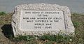 La Route du Nord dedication stone


Outside links
- Saint John Parish website
- St Jean at Les Pages Jèrriaises
- http://www.wantedworldwide.net/city-guides/jersey/area/88/st_john.html
| Parishes of Jersey |
|---|
|
St Brelade • St Clement • Grouville • St Helier • St John • St Lawrence • St Martin • St Mary • St Ouen • St Peter • St Saviour • Trinity |