River Leven, Yorkshire

The River Leven is a river in the North Riding of Yorkshire, which is a tributary of the River Tees. The Leven rises on Warren Moor, part of Kildale Moor, in the North Yorks Moors and flows to the north of the moors to join the River Tees at Yarm.
Course
The source of the river is on Warren Moor, part of Kildale Moor, just south of the village of Kildale. It flows east until it reaches the Whitby to Middlesbrough rail line where it turns dramatically to flow westwards to Kildale.
From Kildale the Leven flows south-south-west through woodland to the confluence with Dundale Beck where it turns north-west through Low Easby and Little Ayton, before turning west and then south-west at Great Ayton.
The A173 road to Stokesley runs parallel to the river Leven for some time.
The river increases in the amount of meanders as continues south-west past Skutterskelfe to Hutton Rudby and Rudby, where it turns north-west and then west again over Slape Stones waterfall. At Crathorne it turns north and then north-east as far as Middleton-on-Leven before passing under the A19 in a north-westerly direction.
The final couple of miles are north and north-west between Ingleby Barwick and Yarm, before the river joins the River Tees.[1]
Geology
The river drains from the Cleveland Hills across a mixed geology of mostly Permian and Jurassic age bedrock of low permeability. Most of the deposits on top of the bedrock are boulder clay. There is mixed agriculture, with some moorland and forestry near the source.[2]
Natural History
Due to a weir on the lower river built during the Industrial Revolution, migratory and territorial fish and mammals had been missing from the river. In 2007, the Environment Agency built a fish bypass at the weir and in 2011, was able to announce the return of spawning Salmon to the river for the first time in 150 years.[3]
Historical interest
In Stokesley, the river is crossed by a 17th Century Pack Horse Bridge, which was once the only crossing into the town.[4] The Domesday Book records the existence of a water mill on the banks of the river in the town.[5] In Hutton Rudby there is a plaque on a bridge that marks the spot of a water mill that, amongst several uses, once made sailcloth.[6]
Tributaries
|
|
Towns and villages on the river
|
|
Pictures
-
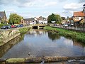
 Bridge over the Leven at Great Ayton
 -
 Coul Beck joining the River Leven near Rudby
 -
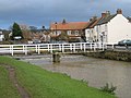
 Leven Bridge over the River Leven at Low Leven
 -
 River Leven, Great Ayton
 -
 River Leven, Low Green, Great Ayton


Sources
References
- ↑ "Moors Knowledge". http://www.yorkshiremoors.co.uk/gazetteer/river_leven.html. Retrieved 24 August 2011.
- ↑ "Geology". http://www.ceh.ac.uk/data/nrfa/data/station.html?25005. Retrieved 24 August 2011.
- ↑ "Salmon returns". http://www.grdp.org/news/130731.aspx. Retrieved 24 August 2011.
- ↑ "Local history". http://www.northyorkshiretowns.co.uk/towns/stokesley.html. Retrieved 24 August 2011.
- ↑ "Stokesley History". http://www.visit-stokesley.com/History-Stokesley.html. Retrieved 21 August 2011.
- ↑ "Hutton Rudby History". http://www.visit-stokesley.com/History-Hutton-Rudby.html. Retrieved 24 August 2011.