Rathtoe
Jump to navigation
Jump to search
| Rathtoe Irish: Ráth Tó | |
| County Carlow | |
|---|---|
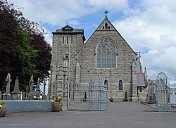
 St Patrick's Church, Rathtoe | |
| Location | |
| Grid reference: | S810712 |
| Location: | 52°47’13"N, 6°47’56"W |
| Data | |
| Population: | 304 (2016) |
| Local Government | |
Rathtoe (otherwise written Rathoe[1]) is a village and townland in County Carlow, in the civil parish of Gilbertstown,[2] between Tullow and Ballon, County Carlow.[1] The Burren River flows through the area.
As a census town, Rathtoe had a population of 304 as of the 2016 census.
The name of the village is from the Irish Ráth Tó.[2]
History and archaeology
Evidence of ancient settlement in the area include the Bronze Age settlement of Ballon Hill (four miles to the south), and a ringfort (rath) within Rathtoe townland itself.[3]
The local Roman Catholic church is dedicated to St Patrick and was built around 1890.[4]
The nearby credit union building was formerly a school, and dates to 1837.[5]
Sport
- Gaelic football: Fighting Cocks GAA
References
- ↑ 1.0 1.1 "Rathtoe". https://carlowtourism.com/rathoe/. Retrieved 31 May 2021.
- ↑ 2.0 2.1 Ráth Tó / Rathtoe: Placenames Database of Ireland
- ↑ Archaeological Inventory of County Carlow. Dublin: Government Stationery Office. 1993.
- ↑ "Saint Patrick's Catholic Church, Rathoe Cross Roads, Rathtoe, Carlow". National Inventory of Architectural Heritage. https://www.buildingsofireland.ie/buildings-search/building/10301301/saint-patricks-catholic-church-rathoe-cross-roads-rathtoe-carlow. Retrieved 31 May 2021.
- ↑ "Rathoe Credit Union, Rathoe Cross Roads, Rathtoe, Carlow". National Inventory of Architectural Heritage. https://www.buildingsofireland.ie/buildings-search/building/10301302/rathoe-credit-union-rathoe-cross-roads-rathtoe-carlow. Retrieved 31 May 2021.