Portwrinkle
| Portwrinkle Cornish: Porthwykkel | |
| Cornwall | |
|---|---|
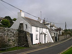
 Houses on the Seafront Road, Portwrinkle | |
| Location | |
| Grid reference: | SX357539 |
| Location: | 50°21’43"N, 4°18’40"W |
| Data | |
| Post town: | Torpoint |
| Postcode: | PL11 |
| Dialling code: | 01503 |
| Local Government | |
| Council: | Cornwall |
| Parliamentary constituency: |
South East Cornwall |
Portwrinkle is a small, coastal village in south-eastern Cornwall, at the western end of Whitsand Bay, five miles south-west of Saltash.
Portwinkle was traditionally a fishing village and the old 17th century walls of the pilchard cellars are still standing, although they have been incorporated into housing. The village has a harbour and two beaches are accessible from it. Although the village has no shops, apart from the beach car park café, there is a post office in nearby village of Crafthole.
Eglarooze Cliff
Eglarooze Cliff (from the Cornish Eglos Ros), to the west of the village, is designated a Site of Special Scientific Interest for its biological interest. The cliff is noted to contain two endangered plant species; the slender bird's-foot trefoil and carrot broomrape.[1]
Outside links
| ("Wikimedia Commons" has material about Portwrinkle) |
References
- ↑ SSSI listing and designation for Eglarooze Cliff