Monikie
| Monikie | |
| Angus | |
|---|---|
 Monikie Church, at Kirkton of Monikie | |
| Location | |
| Grid reference: | NO499387 |
| Location: | 56°32’15"N, 2°48’58"W |
| Data | |
| Population: | 479 (est.) |
| Post town: | Dundee |
| Postcode: | DD5 |
| Dialling code: | 01382 |
| Local Government | |
| Council: | Angus |
| Parliamentary constituency: |
Dundee East |
Monikie is a village in Angus, north-east of Dundee, and which takes its name from the parish of Monikie.
History
The village grew from small beginnings as just one of many hamlets. The other large village in the parish is Newbigging. Because of the siting of the Railway Station, provided mainly to service the farming community and latterly, the Farina Mill or Granary, and the former reservoir ponds for Dundee City Council (now Monikie Country Park), the concentration has centred around the area which became Monikie village, mainly as a result of a new house building programme in the 1970s and 1980s.
The name of Monikie stretched beyond the village to name a wider parish stretching from Hynd Castle in the north, to the coast of the Firth of Tay at the south. Its population in 1991 was 479.[1] Monikie is the northernmost Church of Scotland parish of the Presbytery of Dundee.
Landmarks
Affleck Castle, formerly Auchinleck Castle, stands on the western outskirts of the village toward the centre of the parish. It consists of a tower built on high ground. The castle was inhabited as late as 1746, although it has since been used as a granary. The 17th-century Panmure House, seat of the Earl of Panmure, was located to the east of the village, although it was demolished in the 1950s. Only the stables and the 105-foot Panmure Testimonial remain on the estate, as well as the remains of the earlier Panmure Castle.
Pictures
-
 The Camus Cross
 -
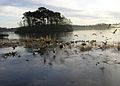 Monikie reservoir Originally built to supply water to Dundee


Outside links
| ("Wikimedia Commons" has material about Monikie) |
References
- ↑ "Details of Monikie". Scottish-places.info. 2004-08-15. http://www.scottish-places.info/towns/towndetails398.html. Retrieved 2013-03-26.