Merston
Jump to navigation
Jump to search
| Merston | |
| Sussex | |
|---|---|
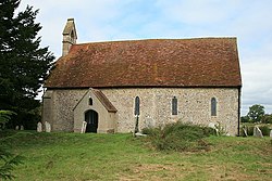
 St. Giles Church, Merston | |
| Location | |
| Grid reference: | SU895028 |
| Location: | 50°49’5"N, -0°43’51"W |
| Data | |
| Post town: | Chichester |
| Postcode: | PO20 |
| Local Government | |
| Council: | Chichester |
| Parliamentary constituency: |
Chichester |
Merston is a tiny hamlet in Sussex, found just south of the A259 road, two and a half miles south-east of the county town, Chichester, in the east of the county strung along a single, narrow lane running south from the Chichester to Bognor road.
History
Merston was listed in the Domesday Book of 1086 as having 16 households, meadows, plough land, and three mills.[1]
In 1861, Merston parish's population was 79, and the parish was 710 acres.[2]
RAF Merston
Nearby was RAF Merston, a Second World War airfield.[3] The airfield was in use from 1939 to 1945.[4]
Outside links
| ("Wikimedia Commons" has material about Merston) |
References
- ↑ Merston in the Domesday Book
- ↑ Information on Merston from GENUKI
- ↑ "Merston". Airfields of Britain Conservation Trust. http://www.abct.org.uk/airfields/airfield-finder/merston/. Retrieved 16 June 2019.
- ↑ Lee, David (2005). Action Stations Revisited: The Complete History of Britain's Military Airfields. 3: South East England. Manchester, England: Crécy. pp. 224–225. ISBN 9780859791106. https://archive.org/details/actionstationsre0003leed.