Maisemore
| Maisemore | |
| Gloucestershire | |
|---|---|
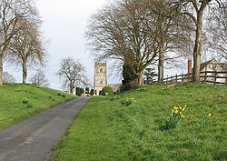
 St Giles Parish church | |
| Location | |
| Grid reference: | SO814212 |
| Location: | 51°53’20"N, 2°16’16"W |
| Data | |
| Population: | 458 |
| Post town: | Gloucester |
| Postcode: | GL2 |
| Dialling code: | 01452 |
| Local Government | |
| Council: | Tewkesbury |
| Parliamentary constituency: |
Forest of Dean |
Maisemore is a village in Gloucestershire, on the west bank of the River Severn and on the A417 road two and a half miles north-west of Gloucester.
In the 2011 census the parish had a population of 458.
The parish includes the hamlet of Overton, a mile north-west of the village.
Geography
Maisemore Bridge connects the village to Alney Island, and provides a viewpoint for the Severn bore. Maisemore Weir and Lock were built in about 1870.[1] The weir is at the upper limit of the tides on the Severn. The lock is no longer in use.
The area is prone to flooding, which from time to time closes the A417 between Maisemore and Gloucester, especially in the spring when the swollen River Severn meets high tides coming up the estuary.
History
The name of the village appears to be of Welsh origin, meaning "great field" (maes mawr).[2] The northern part of Alney Island, which is within the parish of Maisemore, is known as Maisemore Ham, the suffix being from an Old English word for 'meadow.
The village was originally clustered around the church. Probably in the 14th century, the present linear village was replanned further south, leaving the church separated from its settlement.[3]
Parish church
The parish church, dedicated to St Giles, is a Grade II* listed building, dating from the 15th century.[4][5]
Maisemore Court
Maisemore Court, near the church, is a former manor house, also a Grade II* listed building.[6]
Maisemore Bridge

The construction of the current bridge was commenced in 1939 but was stopped during the war of 1939-45. It was completed in 1956.
The bridge stands on or near the site of at least six previous bridges. The first recorded one had a cross with an inscription stating it was begun by William Fitz Anketil circa A.D. 1230.
The next known bridge was recorded as "cut down" by royalist besiegers of Gloucester in 1643 which suggests it might have been a wooden structure: It is known to have been rebuilt of timber.
The parishioners of Maisemore were, by ancient custom, liable for the repair of the bridge, but this apparently proved beyond their means as in 1709, they were fined £200 for non-repair. At the same time the County Justices voted £200 towards "a good substantial brick and stone bridge". The latter as destroyed by great floods and in 1777, trustees were established by act of parliament to build a new bridge in place of a temporary wooden one which had been built lower down the river. A new two-arch brick bridge was begun in 1785 by Thomas Badford, the cost being defrayed by tolls levied by the trustees until 1795.
The trustees continued to maintain the bridge until 1936, when by agreement their powers were ceded to the Gloucester County Council. This bridge was demolished in 1939 to make way for the present structure and a temporary timber bridge was erected which carried the traffic from 1939 to 1956.
Outside links
| ("Wikimedia Commons" has material about Maisemore) |
References
- ↑ Gloucester Quays and Docks: A History of the County of Gloucester - Volume : {{{2}}} (Victoria County History)
- ↑ Mills, A.D. and Room, A, A Dictionary of British Place-Names Oxford University Press
- ↑ A History of the County of Gloucester - Volume 13 p : Maismore (Victoria County History)
- ↑ National Heritage List 1171533: Church of St Giles
- ↑ Maisemore, St Giles - A Church Near You
- ↑ National Heritage List 1091377: Maisemore Court