Kilmuir, Skye
| Kilmuir Gaelic: Cille Mhoire | |
| Inverness-shire | |
|---|---|
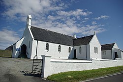
 Kilmuir and Stenscholl Church | |
| Location | |
| Grid reference: | NG384706 |
| Location: | 57°38’56"N, 6°23’6"W |
| Data | |
| Post town: | Dunvegan |
| Postcode: | IV55 |
| Local Government | |
| Council: | Highland |
Kilmuir is a village and parish on the Trotternish peninsula of the Isle of Skye in Inverness-shire. It is the most northern parish on Skye. The name signifies the “Church of Mary”, and is derived from the Gaelic words Cill, a chapel, or burying-ground, and Muire, Mary. It lies 18 miles north-west of Portree.
It is the only place apart from the Western Isles where Scottish Gaelic is spoken by about half of the population.[1] Flora MacDonal, who assisted Bonnie Prince Charlie to escape from Scotland after his defeat at Culloden, is buried in the cemetery here.
History
Within the parish lies Blàr a' Bhuailte (57°37’29"N, 6°16’52"W),[2]), the "field of the stricken", where the Vikings made their last stand in Skye near Loch Leum na Luirginn.
Kilmuir was formerly famous for its pipers; but they are now extinct. The leading performers and teachers of this ancient and martial music were the MacArthurs. A little green hill in close vicinity to Piengowen, called Cnoc-phail, was the general rendezvous of the MacArthurs and their pupils. To the top of this hill they went daily to practice their tunes.
Notes and references
- ↑ Mac an Tàilleir, Iain (2004) 1901–2001 Gaelic in the Census. Linguae Celticae. Retrieved 1 June 2008.
- ↑ Site Record for Skye, Blair A'Bhuailte, Kilmuir, Royal Commission on the Ancient and Historical Monuments of Scotland, http://canmore.rcahms.gov.uk/en/site/11368/
| ("Wikimedia Commons" has material about Trotternish Kilmuir, Skye) |
This Inverness-shire article is a stub: help to improve Wikishire by building it up.