Hardington Mandeville
| Hardington Mandeville | |
| Somerset | |
|---|---|
 Broadstone Villas | |
| Location | |
| Grid reference: | ST515115 |
| Location: | 50°54’3"N, 2°41’28"W |
| Data | |
| Population: | 585 (2011[1]) |
| Post town: | Yeovil |
| Postcode: | BA22 |
| Local Government | |
| Council: | South Somerset |
| Parliamentary constituency: |
Yeovil |

Hardington Mandeville is a village and parish in Somerset, situated three miles south-west of Yeovil. The village has a population of 585.[1]
History
The Hardington part of the name of the village means settlement of Heardred's people.[2]
The manor was held before the Norman Conquest by Gunhilda, the daughter of Godwin, Earl of Wessex and then by William the Conqueror. during the 12th century it was granted to the Mandeville family, from which the second part of the name is taken. It was later held by the Portmans of Orchard Portman.[2]
The parish forms part of the hundred of Houndsborough.[3]
Geography
Nearby is the Hardington Moor biological Site of Special Scientific Interest and National Nature Reserve where the meadows are examples of species-rich unimproved neutral grassland, which is now nationally rare. The rare French oat-grass is very abundant on the site and the fields are home to a wide variety of plant species, most notably adder's tongue, corky-fruited water-dropwort and large numbers of green-winged orchid. Invertebrates found at the site include butterflies such as gatekeeper, small tortoiseshell and common blue. Less commonly seen are large skipper, green-veined white and green hairstreak.[4]
Religious sites
The Church of Saint Mary was rebuilt in 1123 on the site of an earlier church. It has had renovation work in the 15th century and again in 1864. The circular font is thought to be original dating from 1123, and the clock mechanism was built and installed before 1707. There are six bells in the tower, three of which are from the Purdue (Closworth) foundry, with the earliest being dated 1591. It has been designated as a Grade-II* listed building.[5]
-
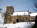 Church of the Blessed Virgin Mary
 -
 Memorial window - St Mary's


References
| ("Wikimedia Commons" has material about Hardington Mandeville) |
- ↑ 1.0 1.1 "Statistics for Wards, LSOAs and Parishes — SUMMARY Profiles" (Excel). Somerset Intelligence. http://www.somersetintelligence.org.uk/files/Somerset%20Census%20Key%20Statistics%20-%20Summary%20Profiles.xls. Retrieved 4 January 2014.
- ↑ 2.0 2.1 Bush, Robin (1994). Somerset: The Complete Guide. Dovecote Press. p. 111. ISBN 1-874336-26-1.
- ↑ "Somerset Hundreds". GENUKI. http://www.genuki.org.uk/big/eng/SOM/Miscellaneous/. Retrieved 9 October 2011.
- ↑ Hardington Moor NNR
- ↑ "Church of Saint Mary". Images of England. English Heritage. http://www.imagesofengland.org.uk/Details/Default.aspx?id=263726. Retrieved 16 February 2009.