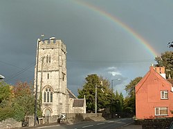
Flax Bourton
| Flax Bourton | |
| Somerset | |
|---|---|
 Church of St Michael and All Angels, Flax Bourton | |
| Location | |
| Grid reference: | ST505695 |
| Location: | 51°25’20"N, 2°42’40"W |
| Data | |
| Population: | 715 (2011) |
| Post town: | Bristol |
| Postcode: | BS48 |
| Dialling code: | 01275 |
| Local Government | |
| Council: | North Somerset |
| Parliamentary constituency: |
North Somerset |
Flax Bourton is a village in Somerset, on the edge of Nailsea Moor by the A370 road five miles south-west of Bristol city centre.
The parish had a population of 715 at the 2011 census.
The village has a primary school, one pub named The Jubilee Inn, a church dating back to Norman times and is the home of Backwell Flax Bourton Cricket Club.
Parish church
The parish church, the Church of St Michael and All Angels, has 12th-century origins and has been designated as a Grade II* listed building.[1]
History
Backwell Hillfort between Flax Bourton and Backwell is an Iron Age hill fort.[2]
To the north of the village and close to the Bristol to Exeter railway line a mill was built on the Land Yeo. A mill here may have existed at the time of the Domesday Book and strong documentary evidence exists from 1769. Between 1839 and 1885 the river was diverted into the tailrace of the mill, eliminating a bend in the river. All that remains of the three storey mill is a single storey garage of a private house.[3]
Farleigh Hospital and the Church of St. George was built in 1837 as a Workhouse for the Bedminster Union.[4] Also on Old Weston Road is the former Long Ashton Magistrate's Court and Police Station, which was built 1857-58 by John Norton,[5] and is now home to the local Coroner's court.
A Ministry of Defence fuel depot, part of the Government Pipelines and Storage System with its own railway sidings, is just off the main line behind the former station. Its future is currently under review.[6] It was constructed between 1954 and 57 by Esso as part of the North Somerset Complex of sites and pipelines for the storage of white oil products. It was originally connected by five pipelines but only one was operational by 1990. It was originally designed for distribution by road and rail with two rail gantries and three road gantries. The site was emptied and closed in the early 1990s following the end of the Cold War. [7]
Geography
Stancombe Quarry was first built in 1952. Today, the quarry which is operated by Tarmac, produces Carboniferous Limestone, which is mainly for use on the roads, after crushing on site.[8] The site has an expected output of 28 million tonnes over a 25-year period.
Outside links
| ("Wikimedia Commons" has material about Flax Bourton) |
References
- ↑ National Heritage List 1129835: St Michael and All Angels Church
- ↑ Megalithic Portal: Backwell Hillfort
- ↑ Bodman, Martin. "Mills on the Land Yeo". Nailsea and District Local History Society. http://somersetrivers.org/PDF/MillsOnTheLandYeo.pdf. Retrieved 28 April 2011.
- ↑ National Heritage List 1137793: Farleigh Hospital and the Church of St George
- ↑ National Heritage List 1129837: Long Ashton Magistrate's Court and Police Station
- ↑ "Taylor Wimpey plans to build 800 new homes and a primary school next to a major fuel depot". Secret Bases. https://www.secret-bases.co.uk/secret3.htm?permalink=GPSS. Retrieved 29 January 2011.
- ↑ Tim Whittle: Fuelling the Wars - PLUTO and the Secret Pipeline Network 1936 to 2015 published 2017 p212. ISBN 9780992855468
- ↑ "Hazemag at Stancombe Quarry". Aggregates and Recycling Information Network. Archived from the original on 7 July 2011. https://web.archive.org/web/20110707093542/http://www.agg-net.com/case-study/hazemag-at-stancombe-quarry. Retrieved 29 January 2011.