File:Stromness-Bay.jpg
From Wikishire

Size of this preview: 800 × 493 pixels. Other resolution: 320 × 197 pixels.
Original file (1,792 × 1,104 pixels, file size: 937 KB, MIME type: image/jpeg)
Summary
- Description
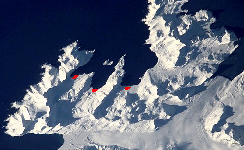
English: Satellite image of central South Georgia Island - Antarctic region.
- Stromness Bay: with Husvik, Stromness, and Leith Harbours; and peninsulas.
- Image
- Science and Analysis Laboratory, NASA-Johnson Space Center. "The Gateway to Astronaut Photography of Earth."
<http://eol.jsc.nasa.gov/scripts/sseop/QuickView.pl?directory=ESC&ID=ISS002-E-10079> (10/01/2007 15:24:24)
Source [1]
This image or video was catalogued by one of the centers of the United States National Aeronautics and Space Administration (NASA) under Photo ID: ISS002-E-10079. This tag does not indicate the copyright status of the attached work. A normal copyright tag is still required. See Commons:Licensing. Other languages:
|
Licensing
| This file is in the public domain in the United States because it was solely created by NASA. NASA copyright policy states that "NASA material is not protected by copyright unless noted". (See Template:PD-USGov, NASA copyright policy page or JPL Image Use Policy.) | ||
 |
Warnings:
|
| Annotations | This image is annotated: View the annotations at Commons |
File history
Click on a date/time to view the file as it appeared at that time.
| Date/Time | Thumbnail | Dimensions | User | Comment | |
|---|---|---|---|---|---|
| current | 16:00, 30 September 2017 | | 1,792 × 1,104 (937 KB) | SteinsplitterBot | Bot: Image rotated by 180° |
File usage
The following file is a duplicate of this file (more details):
- File:Stromness-Bay.jpg from a shared repository
The following 4 pages link to this file: