File:Mendip Hills Map.png
From Wikishire

Size of this preview: 800 × 470 pixels. Other resolution: 320 × 188 pixels.
Original file (2,512 × 1,476 pixels, file size: 1.3 MB, MIME type: image/png)
Summary
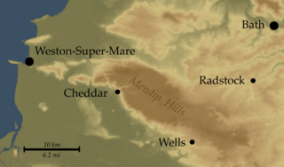
| Description | Map of Mendip Hills, England |
| Date | |
| Source | Topo data from NASA SRTM, PD |
| Author | Myself |
Licensing
I, the copyright holder of this work, hereby publish it under the following license:
This file is licensed under the Creative Commons Attribution-Share Alike 2.5 Generic license.
- You are free:
- to share – to copy, distribute and transmit the work
- to remix – to adapt the work
- Under the following conditions:
- attribution – You must give appropriate credit, provide a link to the license, and indicate if changes were made. You may do so in any reasonable manner, but not in any way that suggests the licensor endorses you or your use.
- share alike – If you remix, transform, or build upon the material, you must distribute your contributions under the same or compatible license as the original.
File history
Click on a date/time to view the file as it appeared at that time.
| Date/Time | Thumbnail | Dimensions | User | Comment | |
|---|---|---|---|---|---|
| current | 21:29, 12 March 2007 | | 2,512 × 1,476 (1.3 MB) | SFC9394 | {{Information |Description= Map of Mendip Hills, England |Source=Topo data from NASA SRTM, PD |Date=12-03-07 |Author=Myself |Permission= |other_versions= }} |
File usage
The following file is a duplicate of this file (more details):
- File:Mendip Hills Map.png from a shared repository
The following page links to this file: