File:Kennet and avon canal locks.png
From Wikishire

Size of this preview: 800 × 158 pixels. Other resolution: 320 × 63 pixels.
Original file (2,702 × 534 pixels, file size: 938 KB, MIME type: image/png)
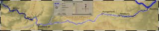
Map of Kennet and Avon Canal Locks, England.
Topography data derived from NASA SRTM, PD.
River Route derived from 1890 OS Mapping, PD by Berne Convention.
This file is licensed under the Creative Commons Attribution 2.5 Generic license.
- You are free:
- to share – to copy, distribute and transmit the work
- to remix – to adapt the work
- Under the following conditions:
- attribution – You must give appropriate credit, provide a link to the license, and indicate if changes were made. You may do so in any reasonable manner, but not in any way that suggests the licensor endorses you or your use.
File history
Click on a date/time to view the file as it appeared at that time.
| Date/Time | Thumbnail | Dimensions | User | Comment | |
|---|---|---|---|---|---|
| current | 12:57, 14 October 2006 | 2,702 × 534 (938 KB) | SFC9394 | Map of Kennet and Avon Canal Locks, England. Topography data derived from NASA SRTM, PD. River Route derived from 1890 OS Mapping, PD by Berne Convention. {{CC-BY-2.5}} |
File usage
The following file is a duplicate of this file (more details):
- File:Kennet and avon canal locks.png from a shared repository
The following page links to this file: