File:Hudders Staly Pylon.jpg
From Wikishire

Size of this preview: 449 × 600 pixels. Other resolution: 180 × 240 pixels.
Original file (483 × 645 pixels, file size: 94 KB, MIME type: image/jpeg)
Summary
| Description |
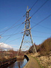
English: Electricity pylon (National Grid tower designation 4ZO251B) straddling the Huddersfield Narrow Canal at Heyrod, near Stalybridge |
| Date | Taken on 27 January 2004 |
| Source | Own work |
| Author | Iain Hart (user Iain4724) |
| Camera location | | View this and other nearby images on: OpenStreetMap |
|---|
Licensing
| This work has been released into the public domain by its author, Iain Hart at English Wikipedia. This applies worldwide. In some countries this may not be legally possible; if so: Iain Hart grants anyone the right to use this work for any purpose, without any conditions, unless such conditions are required by law. |
Original upload log
Transferred from en.wikipedia to Commons by Common Good using CommonsHelper.
The original description page was here. All following user names refer to en.wikipedia.
- 2005-12-09 01:52 Iain4724 483×645× (121327 bytes) I (Iain Hart - iain@cs.man.ac.uk) took this photo of Stalybridge electricity pylon on 27th January 2004. It is my own work and is not subject to any copyright and is free to be copied by anyone.
File history
Click on a date/time to view the file as it appeared at that time.
| Date/Time | Thumbnail | Dimensions | User | Comment | |
|---|---|---|---|---|---|
| current | 07:26, 6 January 2016 | | 483 × 645 (94 KB) | Kreuzschnabel | brightened, warmer colours |
File usage
The following file is a duplicate of this file (more details):
- File:Hudders Staly Pylon.jpg from a shared repository
The following page links to this file: