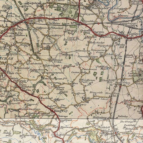
File:Aa oldwythenshawe 00.jpg
From Wikishire

Size of this preview: 600 × 600 pixels. Other resolution: 240 × 240 pixels.
Original file (1,275 × 1,275 pixels, file size: 430 KB, MIME type: image/jpeg)
Summary
| Description | |
| Date | between 1925 and 1945 |
| Source |
http://www.ponies.me.uk/maps/osmap.html Transferred from en.wikipedia to Commons by User:Innotata using CommonsHelper. |
| Author | Ordnance Survey |
Licensing
This work is an Ordnance Survey map over 50 years old, which is covered by Crown Copyright which in this case expires 50 years after publication. Ordnance Survey does however ask that they be credited and that the date of publication be given.
Any ancillary rights gained through the creation of the electronic version are granted as freely usable under any circumstances.
|
This work created by the United Kingdom Government is in the public domain.
This is because it is one of the following:
HMSO has declared that the expiry of Crown Copyrights applies worldwide (ref: HMSO Email Reply)
|
 |
Original upload log
The original description page was here. All following user names refer to en.wikipedia.
- 2011-07-08 18:25 Anthony Appleyard 1275×1275× (349571 bytes) {{Information |Description = Old (around 1925 to 1945) [[Ordnance Survey]] map of [{Wythenshawe]] and [[Manchester Airport]] area |Source = http://www.ponies.me.uk/maps/osmap.html |Date = ~~~~~ |Author = |Permission
File history
Click on a date/time to view the file as it appeared at that time.
| Date/Time | Thumbnail | Dimensions | User | Comment | |
|---|---|---|---|---|---|
| current | 09:53, 4 December 2013 | | 1,275 × 1,275 (430 KB) | Anthony Appleyard | The previous image, sharpened in Paintshop Pro |
File usage
The following file is a duplicate of this file (more details):
- File:Aa oldwythenshawe 00.jpg from a shared repository
The following 2 pages link to this file: