Eversley Centre
Jump to navigation
Jump to search
| Eversley Centre | |
| Hampshire | |
|---|---|
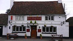
 The White Hart, Eversley Centre | |
| Location | |
| Grid reference: | SU786617 |
| Location: | 51°20’55"N, -0°52’20"W |
| Data | |
| Post town: | Hook |
| Postcode: | RG27 |
| Local Government | |
| Council: | Hart |
| Parliamentary constituency: |
North East Hampshire |
Eversley Centre is a village in the very north of Hampshire, close by the River Blackwater, which here forms the border of Berkshire. Its nearest town is Yateley, approximately two miles to the east.
This village is named geographically: to the north-west is Eversley itself, at the bridge over the Blackwater, and to the east is Eversley Cross.
Outside links
| ("Wikimedia Commons" has material about Eversley Centre) |
This Hampshire article is a stub: help to improve Wikishire by building it up.