Eldersfield
| Eldersfield | |
| Worcestershire | |
|---|---|
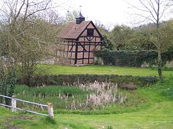
 Village pond | |
| Location | |
| Location: | 51°58’43"N, 2°17’31"W |
| Data | |
| Post town: | Gloucester |
| Postcode: | GL19 |
| Local Government | |
| Council: | Malvern Hills |
| Parliamentary constituency: |
West Worcestershire |
Eldersfield is a village and parish in the Pershore Hundred of Worcestershire. It stands exactly ten miles east of Ledbury and ten miles north of Gloucester; this fact can be found on a milestone on the side of the B4211 road that runs through Corse Lawn.
The parish church is dedicated to St John the Baptist and is in the Diocese of Worcester.[1] The parish registers survive from 1718, and there are bishops' transcripts for the earlier registers starting in 1561.[2] The Savage family were the local worthies and numerous of their 17th-century tombs in the church and graves in the churchyard were recorded by Nash c1780, including Christopher Savage gent. (1600-1681).[3]
Gadbury Camp
The Iron Age fort of Gadbury Camp can be found in the parish, to the east of the village. It is a listed monument.[4][5]
References
- ↑ Church of England, Diocese of Worcester. "St. John the Baptist, Eldersfield". http://www.achurchnearyou.com/eldersfield-st-john-the-baptist/.
- ↑ Good, William. "Eldersfield Registers". http://freepages.genealogy.rootsweb.ancestry.com/~wrag44/eldersfield/eldersfield.htm.
- ↑ Collections for the History of Worcestershire, 2 vols. by Treadway Russell Nash, 1781/2.
- ↑ National Heritage List 1005329: Gadbury Camp, Eldersfield
- ↑ Anon (2015). "Gadbury Camp A Scheduled Monument in Eldersfield, Worcestershire". Good Stuff. https://ancientmonuments.uk/103566-gadbury-camp-eldersfield.
Outside links
| ("Wikimedia Commons" has material about Eldersfield) |
- Eldersfield entry in A History of the County of Worcester: volume 4
- Eldersfield Church
- Eldersfield Marsh
- Marsh Court
- Eldersfield entry in John Noake's Guide to Worcestershire (1868)
This Worcestershire article is a stub: help to improve Wikishire by building it up.