East Prawle
Jump to navigation
Jump to search
| East Prawle | |
| Devon | |
|---|---|
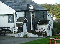
 The Pig's Nose Inn, East Prawle | |
| Location | |
| Grid reference: | SX781363 |
| Location: | 50°12’54"N, 3°42’35"W |
| Data | |
| Post town: | Kingsbridge |
| Postcode: | TQ7 |
| Local Government | |
| Council: | South Hams |
East Prawle is a village in the very south of Devon, on the coast south east of Salcombe near the county's most southerly tip, Prawle Point.
The closest village of any size is Chivelstone (to which civil parish East Prawle has been allocated).
The village is listed in the Domesday Book. Its name comes from the Old English word Præwhyll meaning 'lookout place'.[1] Primarily a farming settlement the village has seen little major development save to meet local requirements.
During the First World War, an airfield was constructed just outside the village.[2]
Local amenities include a public house, local shop, and a community hall.
The village pub is the Pigs Nose.
Outside links
| ("Wikimedia Commons" has material about East Prawle) |