Corscombe
| Corscombe | |
| Dorset | |
|---|---|
 Corscombe village | |
| Location | |
| Grid reference: | ST518053 |
| Location: | 50°50’47"N, 2°41’11"W |
| Data | |
| Population: | 445 (2011) |
| Post town: | Dorchester |
| Postcode: | DT2 |
| Local Government | |
| Council: | Dorset |
| Parliamentary constituency: |
West Dorset |
| Website: | corscombe.org |
Corscombe is a village in Dorset. The wider civil parish includes the small settlements of Benville and Toller Whelme to the south and in the 2011 census had a population of 445.
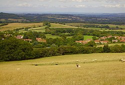
Corscombe village is sited "into hollows and along sunken lanes"[1] on the northern scarp slope of the Dorset Downs, approximately eight miles south of Yeovil in Somerset.
On the higher ground in the village stands the 15th-century parish church of St. Mary, which was restored in 1875–7.[1] In 1905 Sir Frederick Treves Bt described the church as a "handsome building" with an "exceedingly fine" situation.[2] Nearby Corscombe Court dates from the 13th century and is partially surrounded by a moat. It has a 15th-century tithe barn which was once used by the monks of Sherborne Abbey.[3]
About the village
Evidence of early occupation within the parish includes lynchets and, south of the village, three standing stones.[4]
About a mile south of Corscombe village, across the A356, is Toller Down, one of the highest hills in Dorset, with good views of the surrounding countryside.
| ("Wikimedia Commons" has material about Corscombe) |