Carrigadrohid
| Carrigadrohid Irish: Carraig an Droichid | |
| County Cork | |
|---|---|
 Road junction in Carrigadrohid | |
| Location | |
| Grid reference: | W414725 |
| Location: | 51°54’6"N, 8°51’10"W |
| Data | |
| Local Government | |
| Dáil constituency: |
Cork North-West |
Carrigadrohid is a townland and village in County Cork, standing on the north bank of the River Lee, with the nearby village of Canovee to the south.
The name of the village is from the Irish Carraig an Droichid meaning 'Rock of the bridge'.[1]
Castle

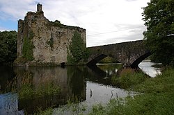
Carrigadrohid castle stands on a rock in the middle of the river Lee, adjacent to the bridge which gives the village its name. It was erected in the 15th century by the MacCarthys of Muskerry, with an extension to the east and an annex to the north being added in subsequent centuries.
The castle was besieged by Cromwellian forces following the Battle of Macroom, and Boetius MacEgan, the Bishop of Ross, was hanged by the reins of his own horse outside the castle having refused to implore the Irish garrison to surrender to the Cromwellian army.
The MacCarthys were dispossessed, and the castle ended up in the hands of the Bowen family. It has been in ruins since the late 18th century. In later years, a local group has been formed with the aim of preserving the castle.
Sport
- Gaelic sports: Canovee GAA Club[2]
References
- ↑ Placenames Database of Ireland. Carraig an Droichid Verified 2011-02-10.
- ↑ Canovee GAA Club