Caldecote, Cambridgeshire
| Caldecote | |
| Cambridgeshire | |
|---|---|
 St Michael and All Angels Church | |
| Location | |
| Grid reference: | TL349575 |
| Location: | 52°12’0"N, 0°1’34"W |
| Data | |
| Population: | 820 (2001) |
| Post town: | Cambridge |
| Postcode: | CB23 |
| Dialling code: | 01954 / 01223 |
| Local Government | |
| Council: | South Cambridgeshire |
| Parliamentary constituency: |
South Cambridgeshire |
Caldecote is a village in the south-west of Cambridgeshire, on a little road running south from the A428, some six miles west of Cambridge and three miles east of the new village of Cambourne.
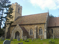
The parish church is St Michael and All Angels, parts of which date to the 14th Century.
Caldecote has split in two through new development: the village of Caldecote itself is a tiny place strung along the lane, just off the B1046 road; this is a traditional Cambridgeshire faming village with church, farms and cottages. To the north near the A428 is a whole new village developed in the parish, set apart from the old village and known as Highfields Caldecote.
Nearby villages are Highfields Caldecote, Hardwick and Toft to the east, Bourn to the west, Childerley further to the north and Kingston to the south. Bourn Airfield lies on the northwest edge of the village. The Bourn Brook runs to the south of the village.
History
Caldecote is listed in the Domesday Book of 1086.[1]
The Oxford and Cambridge Railway, known as the 'Varsity Line' used to run to the south of the village. The line has since been grubbed up.
In the latter half of the twentieth century a new development was begun in to the north of the village, known as Highfields Caldecote, which is now in effect a separate village. The development in Highfields saw a rapid increase in the population of the parish, and even between 2001 and 2010 the parish population increased from an estimated 800 to an estimated 1,690.
Outside links
| ("Wikimedia Commons" has material about Caldecote, Cambridgeshire) |
- Official Caldecote Local History Group Blog
- Caldecote Parish
- St Michael and All Angels
- Caldecote Scout Group
References
- ↑ The Agricultural History of Caldecote, Cambs, accessed 7 September 2007