Bridgetown, Totnes
Jump to navigation
Jump to search
| Bridgetown | |
| Devon | |
|---|---|
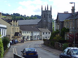
 Bridgetown, looking towards Totnes | |
| Location | |
| Grid reference: | SX809603 |
| Location: | 50°25’51"N, 3°40’41"W |
| Data | |
| Postcode: | TQ9 |
| Local Government | |
| Council: | Teignbridge |
| Parliamentary constituency: |
Teignbridge |
Bridgetown is a part of Totnes in Devon. It is divided from Totnes itself by the River Dart, and came into existence as a result of the first bridge being built across the river at Totnes. The river is in a valley, with Bridgetown on the eastern slope opposite Totnes.
The Dart becomes tidal around the bridge here.

There is a church in Bridgetown, a village hall, two large grassy play areas, a dental surgery, a farm, a butcher, two small corner shops, a Chinese takeaway, one public house, which includes its own brewery, longmarsh a riverside walk also used for military training, a rowing club, a caravan park and a vet.
Outside links
| ("Wikimedia Commons" has material about Bridgetown, Totnes) |