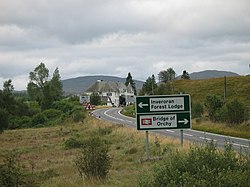
Bridge of Orchy
| Bridge of Orchy Gaelic: Drochaid Urchaidh | |
| Argyllshire | |
|---|---|
 Bridge of Orchy seen from Beinn Dòrain | |
| Location | |
| Location: | 56°31’4"N, 4°46’14"W |
| Data | |
| Post town: | Bridge of Orchy |
| Postcode: | PA36 |
| Local Government | |
| Council: | Argyll and Bute |
| Parliamentary constituency: |
Argyll and Bute |
Bridge of Orchy is a village in Argyllshire, a tiny place barely more than a hamlet, though it has its own church and importance as a place on the road through the midst of the Highlands. The village stands at the head of Glen Orchy, on the A82 road.
The village dates to 1751. It has a notable tourist hotel and a railway station. It is on the West Highland Way long distance path. Nearby prominent peaks include the munros Beinn Dorain and Beinn an Dòthaidh, in a group known as the Bridge of Orchy Hills.
The bridge from which the village is named, and to which it owes its existence, was built by the army as part of a programme of pacification of the Highland clans, which involved the construction of military roads from the Lowlands into the trackless wastes of the Highlands. The bridge crosses the River Orchy, one of the finest white-water rivers in the United Kingdom.
See also
Outside links
| ("Wikimedia Commons" has material about Bridge of Orchy) |