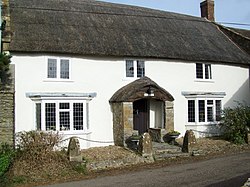
Beer Hackett
Jump to navigation
Jump to search
| Beer Hackett | |
| Dorset | |
|---|---|
 Church Farm, Beer Hackett | |
| Location | |
| Grid reference: | ST600118 |
| Location: | 50°54’16"N, 2°34’17"W |
| Data | |
| Population: | 100 (2013 est.) |
| Post town: | Sherborne |
| Postcode: | DT9 |
| Local Government | |
| Council: | Dorset |
| Parliamentary constituency: |
West Dorset |
Beer Hackett is a small village in western Dorset, three miles south-west of Sherborne and five mile south-east of Yeovil, the latter in Somerset. The civil parish includes the small settlement of Knighton to the east and the local council's 2013 mid-year estimate of the population of the civil parish is 100.
Beer Hackett is not recorded in the Domesday Book of 1086.[1]
The nave and west tower of the parish church were originally built in the early 15th century, though the whole building was radically restored in the 19th century.[2]
Outside links
| ("Wikimedia Commons" has material about Beer Hackett) |
References
- ↑ Darby, H; Versey, G (2008). Domesday Gazetteer. Cambridge University Press. p. 116. https://books.google.co.uk/books?id=L3dWJnqv5lEC&pg=PA116&lpg=PA116&dq=beer+hackett+domesday&source=bl&ots=OGNy1AsQCg&sig=bxHx1_FYkZdRMh2t0M-4mVfrDmU&hl=en&sa=X&ei=UvDkVIe1DcXY7AamuYHwBg&ved=0CEwQ6AEwBw#v=onepage&q=beer%20hackett%20domesday&f=false. Retrieved 18 February 2015.
- ↑ "'Beer Hackett', in An Inventory of the Historical Monuments in Dorset, Volume 1, West (London, 1952), pp. 27-28". British History Online. University of London. http://www.british-history.ac.uk/rchme/dorset/vol1/pp27-28. Retrieved 18 February 2015.