Barrington, Somerset
| Barrington | |
| Somerset | |
|---|---|
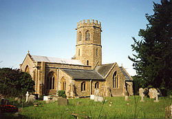
 St Mary the Virgin, Barrington | |
| Location | |
| Grid reference: | ST385185 |
| Location: | 50°57’45"N, 2°52’37"W |
| Data | |
| Population: | 438 (2011) |
| Post town: | Ilminster |
| Postcode: | TA19 |
| Dialling code: | 01460 |
| Local Government | |
| Council: | South Somerset |
| Parliamentary constituency: |
Somerton and Frome |
Barrington is a village in Somerset, standing ten miles south-east of Taunton and ten miles west of Yeovil, in the south of the county. The village is a modest place, which had a recorded population of just 438 at the 2011 census.
The village is in the South Petherton Hundred and at the southern edge of the Somerset Levels. Many of the houses here use local material and are built from cob and thatched with local reeds.
About the village

Barrington Court, the local manor house, is a fine Tudor building which anticipates some features of the later Elizabethan style. It was built around 1514 for Henry Daubeney, 1st Earl of Bridgewater and perhaps finished as late as 1558 for William Clifton. The interior was virtually gutted in 1825, and restored in 1921–25 by Forbes and Tate for A.A. Lyle, having passed to the National Trust in 1908.
The house is a Grade I listed building.[1]
Parish church
The 13th-century Church of St Mary the Virgin has an unusual octagonal tower, which includes a bell dating from 1743 and made by Thomas Bilbie of the Bilbie family.[2] The church is today a Grade I listed building.[3]
Outside links
| ("Wikimedia Commons" has material about Barrington, Somerset) |
- Barrington in the Domesday Book
References
- ↑ National Heritage List 1345920: Barrington Court
- ↑ Moore, James; Rice, Roy; Hucker, Ernest (1995). Bilbie and the Chew Valley clock makers. The authors. ISBN 0-9526702-0-8.
- ↑ National Heritage List 1056904: Church of St. Mary the Virgin