Atherfield
| Atherfield | |
| Hampshire | |
|---|---|
 Atherfield Green | |
| Location | |
| Island: | Isle of Wight |
| Grid reference: | SZ461800 |
| Location: | 50°37’7"N, 1°20’55"W |
| Data | |
| Postcode: | PO38 |
| Local Government | |
| Council: | Isle of Wight |
| Parliamentary constituency: |
Isle of Wight |
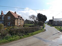
Atherfield is a location on the Isle of Wight, Hampshire. It is in the south of the island, near the coast, in the 'Back of the Wight'. Broadly it includes a several farms, and two tiny hamlets:
- Little Atherfield, a hamlet of two farms and a scatter of cottages;
- Atherfield Green
This is largely open farmland. To the south-west are the cliffs of Chale Bay and Brighstone Bay, which are divided by Atherfield Point. The south-eastern part of Brighstone Bay is also sometimes known as Atherfield Bay, and was the site of a former holiday camp, now demolished.
There are no population figures for the hamlets, as they are counted at the census with the civil parish of Niton and Whitwell.
Geology
Atherfield Bay is one of the best sources of Cretaceous fossils, and is one of the places that gives the Wight the nickname "Dinosaur Isle". The unique land formation on this coast means fossils up to 30 million years old are uncovered.
The bay also marks the landward edge of the Atherfield Ledge, an underwater outcrop that has claimed many ships: the SS Eider and others.[1]
References
- ↑ "Back of the Wight - Ships Graveyard - Shipwrecks on the coast of the Isle of Wight". http://www.backofthewight.co.uk. Retrieved 2 October 2018.
